Live data from Hacker News

Using QGIS to apply a 1777 style to today's OpenStreetMap data

manuelclaeysbouuaert.be

31–40 of 72 posts

Re: Using QGIS to apply a 1777 style to today's OpenStreetMap data

#31
post #11

The old maps had way better contrast, it seems.

Modern Google/Apple maps are incredibly low contrast and I don't know why. Seems like they want to have streets and land stand back to make room for features such as pin locations, buisness markings (advertising) or dedicated layers such as traffic. I really don't get it. Here in Germany, in the last century, "road atlases" were a thing, big maps with great overview and detail maps which were basically at maximum con…
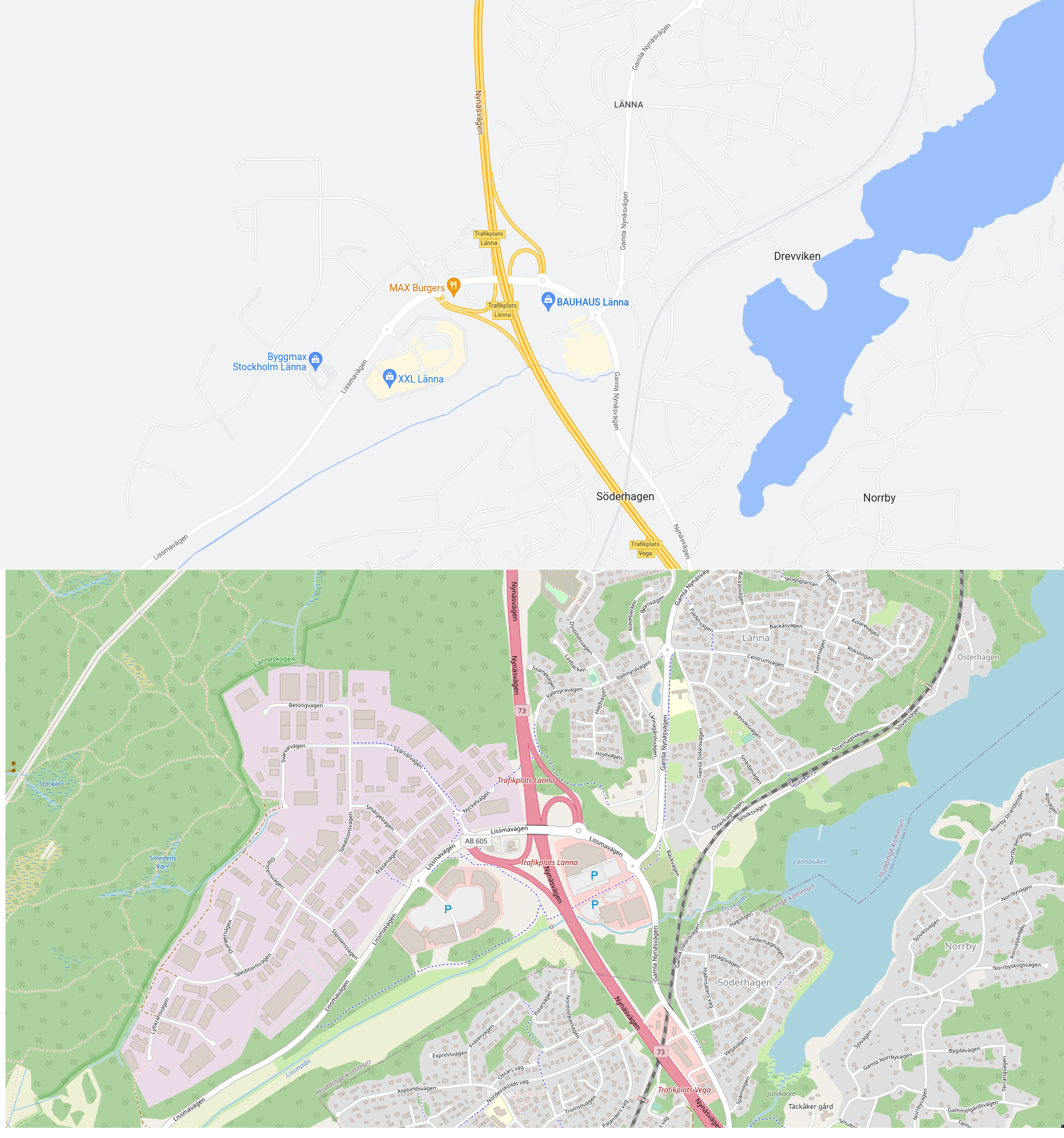
Yeah, this is ridiculous: https://i.xkqr.org/gmapsvsosm.png

The top one is completely unusable if you want to do anything other than drive a car on the highway, in which case it's actually quite good.

(I picked this area specifically because it contains highway, railway, footpaths, water, residential area, industrial area, open fields, forest, and wetland. You wouldn't know, though, if you only looked at the top map. But it's not a location picked to be unfavourable to Google Maps – I sampled a few other places in the world where OSM coverage is likely to be decent, and it's the same story everywhere.)

Re: Using QGIS to apply a 1777 style to today's OpenStreetMap data

#32

Dragging the sliders doesn't work when viewing on a mobile device.

Same here, on Android Chrome.

The JS script that the author is using relies on listening to both mousedown and touchstart events, etc. It isn't clear to me why Android has a problem with that, but I wonder if switching to listening only for pointer events [1] would fix things.

[1] https://developer.mozilla.org/en-US/docs/Web/API/Pointer_eve...

Re: Using QGIS to apply a 1777 style to today's OpenStreetMap data

#33
Nice project, and nice map! I did not know the Ferraris map, it is gorgeous.

It would love to see a tile server of this map, preferably with a switch between the old and the new map.

There is a 'time travel app' for Belgium [1] that includes the Ferraris map, and even older maps. It's a bit clunky, I like the Dutch topotijdreis (topo-time-travel) [2] a lot more, but it seems like the maps are not as old and not as good, I have to slide to 1898 to get a colored map of Amsterdam.

[1] https://www.geopunt.be/kaart?app=Reis_door_de_tijd_app

[2] https://www.topotijdreis.nl/kaart/1898/@122079,487387,9.49

Re: Using QGIS to apply a 1777 style to today's OpenStreetMap data

#34
post #11

The old maps had way better contrast, it seems.

Modern Google/Apple maps are incredibly low contrast and I don't know why. Seems like they want to have streets and land stand back to make room for features such as pin locations, buisness markings (advertising) or dedicated layers such as traffic. I really don't get it. Here in Germany, in the last century, "road atlases" were a thing, big maps with great overview and detail maps which were basically at maximum con…

On that note, one thing I've wanted to do for quite some time is an application that would allow you to open an image file or a set of image files with a particular style of map and it would try to replicate that style with OSM data. Ideally emitting that style in a Mapserver mapfile, or a Mapnik style file, or whatever. If you prefer German-style road atlases, you should be able to have them with OSM data. Doing such things by hand seems incredibly tedious, though.

Re: Using QGIS to apply a 1777 style to today's OpenStreetMap data

#35
post #11

The old maps had way better contrast, it seems.

Modern Google/Apple maps are incredibly low contrast and I don't know why. Seems like they want to have streets and land stand back to make room for features such as pin locations, buisness markings (advertising) or dedicated layers such as traffic. I really don't get it. Here in Germany, in the last century, "road atlases" were a thing, big maps with great overview and detail maps which were basically at maximum con…

Road atlases were the same in Spain. I think the reason is that they are not interactive, that's the all the zoom level you are going to get and so they are extremely dense with information.

I think that for interactive use google maps are way better, they avoid information overload by presenting a very schematic representation. Old road atlases look like versions of Where's Waldo?.

Re: Using QGIS to apply a 1777 style to today's OpenStreetMap data

#36
post #29
post #6

Earlier quoted context omitted.

they usually used triangulation, the same as today. they select an line as the startimg point and measure it exactly as possible(doesn't need to be long) and then you can calculate the rest with the measured angles of the area you want to measure. The rest is replicating it on paper with the required factor.

Thanks! It still a bit unclear to me but I'll dig more. Cheers

Here's an example from the original survey of India. https://apps.lib.umich.edu/online-exhibits/exhibits/show/ind...

In the US, if you hike, you'll often find circular USGS survey markers inset into mountain and hill tops.

Re: Using QGIS to apply a 1777 style to today's OpenStreetMap data

#37
Side note: I love this style of "artwork". I also enjoy old books with paintings, older maps and whatnot and can look at them for hours.

Maybe it's because I work in print media and know how fast and good modern tools are, so I can estimate (and value) how complicated it was to create all the graphics in former times.

So: Great project to bring back the old style for modern data.

Re: Using QGIS to apply a 1777 style to today's OpenStreetMap data

#38

The old maps had way better contrast, it seems.

I really miss poring over big sheets of paper to find nice routes to cycle over... Especially in France, the Michelin 200.000 maps are unrivaled to not only find your way, but also have a good feel how the road and the landscape looks like. [1].

These Michelin maps have a great feature I've not seen elsewhere: traffic intensity is rendered with color (white=quiet, red=busy) and road-width is rendered as width, binned at a few standard widths. I would love to see that on openstreetmap.

[1] https://www.viamichelin.nl/static/1.462.0/html/michelinmap.h...

Re: Using QGIS to apply a 1777 style to today's OpenStreetMap data

#39
post #2

It’s crazy to see how much has remained the same, even if so many new things were added. Looks like pretty much all the buildings that existed in 1777 still exist today. Even crazier to think that at the time the original map was made, pretty much all cities in the US didn’t even exist yet.

I purchased a 350 year old roadmap for my locality. It was still usable. The main roads, town placements and landscape features don't shift much!
Post reply on HN