Live data from Hacker News

Google Maps Mystery Actually Spy Satellite Targets

foxnews.com

11–20 of 26 posts

Re: Google Maps Mystery Actually Spy Satellite Targets

#11

"In other words, the Chinese military probably uses radar instruments to send signals down at the target from above, and determine how much radar bounces back to the instruments from the fighter jets..." I'm curious, what type of radar is used in spy satellites? Is there any health risk for people on the ground?

I'm curious, what type of radar is used in spy satellites?

The same kind as on aircraft, basically. Synthetic aperture is one form of radar that's been in use for a while, and I'm sure it's progressed by amazing levels since I was in the game.

Is there any health risk for people on the ground?

Nope, not much more RF radiation that what we get zapped with by terrestrial radiation.
Re: Google Maps Mystery Actually Spy Satellite Targets

#12

Earlier quoted context omitted.

That's somewhat prejudiced, no? Besides, the content is originally from here[1], Fox News just republished it. [1]: http://www.lifeslittlemysteries.com/mystery-structures-china...

That's somewhat prejudiced, no? The point of avoiding Fox is to eschew prejudice, I'd say. You could summarize this story as "Yep, China has spy satellites," which isn't actually news to anyone who's interested. It's exactly the sort of "keep the people afraid" non-news Fox has become infamous for.

Well that's not the entire story. The entire story was, China has these odd things on the ground. What are they? This follow-up just provides an answer to that. You might say "what is the use of the Hubble telescope, all it tells us is "yup, there's more stars"?".

Re: Google Maps Mystery Actually Spy Satellite Targets

#13
post #7

out of curiousity -- could the Manhattan grid be naturally used for satellite calibration (thus masking intention)? Could we install objects on top of buildings to help calibration (surreptitiously)?

If a city grid was sufficient, why would China need to build massive structures in the desert? They've no shortage of city grids. Come to think of it, they've no shortage of massive development projects either. If a city grid worked as a surreptitious calibrating tool, surely they could work the design into a factory system, evap pool project or university campus. (I think an actual city would be out of the question due traffic concerns)

Re: Google Maps Mystery Actually Spy Satellite Targets

#14
post #7

out of curiousity -- could the Manhattan grid be naturally used for satellite calibration (thus masking intention)? Could we install objects on top of buildings to help calibration (surreptitiously)?

Theoretically, maybe, but it's not very practical. You need to have very good ground truth (i.e. know exactly how wide that street is) and the spacecraft needs to be directly above Manhattan, otherwise tall buildings will obscure your calibration target.

FWIW, I was on a calibration support team for the recently launched NPP satellite. The engineers and scientists go to great lengths to perform calibration and characterization before launch. Common calibration targets after launch: deep space, the moon, polar ice caps. Things we know a great deal about, have a clear view to, and don't change much.

Re: Google Maps Mystery Actually Spy Satellite Targets

#18
post #7

out of curiousity -- could the Manhattan grid be naturally used for satellite calibration (thus masking intention)? Could we install objects on top of buildings to help calibration (surreptitiously)?

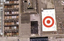
The first thing that comes to mind here is the enormous red bullseyes that Target puts on top of all of its stores. They're visisble from airplanes and satellites, but their symmetry would make them less useful for calibration.

An example: http://craphound.com/images/googleeasrthad.jpg

Re: Google Maps Mystery Actually Spy Satellite Targets

#19
post #5

"In other words, the Chinese military probably uses radar instruments to send signals down at the target from above, and determine how much radar bounces back to the instruments from the fighter jets..." I'm curious, what type of radar is used in spy satellites? Is there any health risk for people on the ground?

The military probably has radar on satellites similar to aircraft-mounted battlefield management systems like JSTARS ( http://en.wikipedia.org/wiki/E-8_Joint_STARS ) Basically, they can identify tanks, buildings, and other large objects via radar. There are also millimeter band radars that can produce images.

Satellites can do much better than just identify large objects. Resolution depends on the aperture width, and a satellite in orbit can pretend to have a very wide aperture indeed...
Post reply on HN