Live data from Hacker News

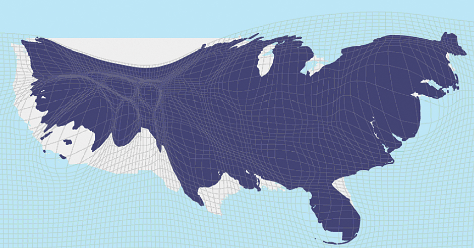
Mapping the U.S. By Property Value Instead of Land Area

citylab.com

111–120 of 173 posts

Re: Mapping the U.S. By Property Value Instead of Land Area

#111

Earlier quoted context omitted.

Exactly. This is making Dallas County look expensive, when in fact it is one of the most affordable major metro areas in the US. The "elite Texas counties" the article refers to are really a figment of data representation. Sure, those counties have neighborhoods or small towns that are stupid expensive, but they are the exception. All of them are highly populous, though; all five dark red counties (Dallas, Tarrant, H…

That doesn't jibe with the map data - land prices in that county are anything but affordable, regardless of how many people live there, right?

The map shows total land price in the county. It doesn't measure anything like affordability of land (which would be measured by something like price / unit area of land) or residential affordability (which would be measured by something like price / unit area of home.)
Re: Mapping the U.S. By Property Value Instead of Land Area

#112

How can the random large splotches be translated into usefulness or meaning? The gif seems to imply that the areas are resized based on their value, that is SUPER not helpful. And the bucket $40b - $1tr?! Almost everything falls in that bucket! I don't think this map is of great value.

I thought that bucket was large too, but then I realized it is only used for color, not size. So size of county is a more granular measure for housing measure, if that's what you're looking for.

EDIT: I see, you're saying the areas are hard to compare. Good point!

Re: Mapping the U.S. By Property Value Instead of Land Area

#113
post #8

Isn't this just the same as population density? I think there's an XKCD about this ... https://xkcd.com/1138/

No— the coasts have substantially higher property values. A cartogram scaled by population is far less dramatically distorted: http://www.esri.com/news/arcuser/0110/graphics/cartogram_3-l... The big cities of Texas and the Great Lakes regions barely show up on the property value map.

Re: Mapping the U.S. By Property Value Instead of Land Area

#114
post #41

Earlier quoted context omitted.

As a lifetime Oregonian, I enjoy Bend and get out there a couple times a year. My family even considered moving there a few years ago in search of a place with more sun. But in deciding between Boulder and Bend, we ended up choosing Boulder, well actually Broomfield, but Boulder was the draw, because as you found Boulder housing prices were too high. Which leads me to the question, did you consider living outside of…

> did you consider living outside of Boulder to still get most of the things on your checklist, but not face the high housing prices or difficult political climate? Yeah, but at that point, you're back to the whole car commute thing, or a really long bike ride. And you're significantly farther from the mountains by bike, too. Fort Collins was something else that looked pretty interesting, but I didn't see many jobs t…

There's a small tech scene in Fort Collins, mostly focused on hardware. Intel, HP, AMD, Broadcom, Avago, LSI, and Microsoft come to mind. (Well, three of those are now one)

A small market like that is good and bad. There is no glut of engineers, so you aren't a cheap throwaway commodity, but options are fewer.

You could use Boulder/Denver/Longmont as your fallback. A sizeable commute, but that adds IBM, NASA, Western Digital, Xilinx, Avaya... and a host of startups.

The real startup scene in Fort Collins is probably microbreweries. Engineers of every type are starting microbreweries.

Re: Mapping the U.S. By Property Value Instead of Land Area

#115

Earlier quoted context omitted.

Really nice piece. I basically moved from SF to Boulder (with stops abroad in between). What you're talking about in the blog is playing out right now with the "make growth pay it's own way". http://openboulder.org/ob-opposes-two-growth-related-ballot-... They are smart people spearheading these anti-growth measures. They want (like you said) the Boulder from 30 years ago. They are motivated, smart, and have the time…

Note: Boulder is great if you already make good money, like a small quiet life, have your partner, and value access to nature over access to people, music, culture, art, etc.

Maybe not the greatest music scene ever, but you are within spitting distance of Denver and Red Rocks.

Re: Mapping the U.S. By Property Value Instead of Land Area

#116

> "The stubborn unwillingness of incumbent homeowners in highly productive places—namely San Francisco and New York City, which are barely visible on the land-area map, but dominate the housing value map—is a huge drain on the nation’s economy." Are they trying to say that if people didn't have to spend as much on housing then there would be greater GDP?

The author might be making a valid point, but the visualization they chose doesn't match their thesis very well.

Think about it: if the homeowners in SF relent, approve massive housing projects, and decrease the average housing price of SF, then more people will now move into SF and its total real estate price (and hence the size of SF in their visualiztion) will increase.

Re: Mapping the U.S. By Property Value Instead of Land Area

#117

The conclusions from the article seemed a bit rushed. NYC and the Bay Area are pretty different when it comes to NIMBY policies and commutes from low income areas to high income.

> NYC and the Bay Area are pretty different when it comes to NIMBY policies and commutes from low income areas to high income. How so? New York has plenty of NIMBY policies and commuters.

In NYC if you need a $1200 / mo 1BR apartment, sure Manhattan and north eastern Brooklyn aren't options but you still have places like Harlem, Queens, New Jersey, The Bronx, Staten Island all of which are under an hour commute from Manhattan (and with a rapid transit system that respects shift workers by running 24hrs a day).

NYC has also been adding high density (albeit market rate) housing stock by the tens of thousands each year since 2013 or so. NIMBY-ism in Bay Area communities tends to be opposed increased density of any sort, but for the most part in NYC it's focused more on the boundaries of low income housing areas.

East coast municipalities also have a lot more power to make mandates without the kind of broad community consensus that California cities have to abide by. So while residents can express opposition to a development plan and sometimes fight it in NYC, NIMBY advocates only carry weight when they're well equipped to battle city hall.

Basically my point is that it's kind of a stretch to draw a conclusion that the same patterns are applicable to both housing markets. The New York metro and the Bay Area metro are very different places with very different policies and political landscapes. New York's inflated housing market has more to do with legacy policies from the Bloomberg administration and real estate speculation than too few units and NIMBY attitudes, which are a much bigger problem in SF

Re: Mapping the U.S. By Property Value Instead of Land Area

#118
A well-known prior art of this idea -- and perhaps not even the first -- is Worldmapper at http://www.worldmapper.org/. "The world as you have never seen before" contains striking world maps with their areas proportional to measures like population (even the population in AD 1), income, aircraft flights, toy exports, nuclear weapons, languages, people killed by floods and 600 more.

Re: Mapping the U.S. By Property Value Instead of Land Area

#119
post #109

Earlier quoted context omitted.

From your blog, it looks like you were pricing sizable houses rather than higher density housing like a 2br/2ba condo, which can be found for much less. Although I grew up in Alaska, I have no regrets about buying a modest condo next to trails and with a short bike commute instead of a larger place further from everything I care about. Anyway, there would be more incentive to build high-density housing if more people…

Prices are lower all across the board in Bend. We were looking into some townhouses in Boulder, and they're still several hundred dollars more than what we pay in a nice part of Bend within walking distance of downtown.

Obviously, but no amount of high-density construction in Boulder will make it cheaper than equivalent accommodations in Bend (unless Bend gets a lot more expensive).

I'm not questioning your decision, but it's worth being realistic about what high-density construction could achieve.

Re: Mapping the U.S. By Property Value Instead of Land Area

#120
post #57
post #20

Earlier quoted context omitted.

I think that if rents weren't such a drain, then yes, you could spend the money on other things and drive up GDP. SF currently has bad rents that are hurting the local economy. Money that just a few years ago was going to eating out, new cars, vacations, etc. is now going to a greedy landlord.

Monies spent on rent are already included in the GDP; they don't depress it.

I think he is alluding that high rent leads to wealth concentration. A lot of salaried people can invest a tiny bit in a much larger variety of interests than a few wealthy, or choose to work on something less profitable while still making rent. These investments by a lot of people will at some point lead to unexpected value creations that increase GDP. At least that is the tenet of a consumer and market economy.
Post reply on HN