Earlier quoted context omitted.
Please. No Electron!
Why not?
There are very good electron apps, but the engineering to make them small and fast is quite important.
31–40 of 108 posts
Earlier quoted context omitted.
Please. No Electron!
Why not?
There are very good electron apps, but the engineering to make them small and fast is quite important.
Note from the developer: I’m so glad that many of you like this app. I’m a solo dev, actively building between my 9-5 and raising a 9mo. Please follow along on X https://x.com/benlimner , or join the mailing list for updates/suggestions!
At the same time, I'm not sure how you monetize such an easily "stealable" idea. My hunch is that you'll see other flight trackers debut your perspective as one of many layers within their own trackers (this is where you come in, as consultant?).
Godspeed, ace.
Note from the developer: I’m so glad that many of you like this app. I’m a solo dev, actively building between my 9-5 and raising a 9mo. Please follow along on X https://x.com/benlimner , or join the mailing list for updates/suggestions!
I noticed one minor area for potential improvement: when I look at the ATL area right now, it looks like aircraft are clipping through the ground at takeoff and landing.
I'm guessing this is because you're taking the pressure altitude which is derived from aircraft transponder data, and incorrectly interpreting it as altitude above sea level, without correcting for local air pressure variations. Right now, local barometric pressure in Atlanta is about 1028 mbar, which means pressure altitude is about 450 feet lower than true MSL altitude.
(Pilots need to know their altitude relative to sea level and the ground, so they have to manually adjust their altimeters to correct for pressure variations, based on the latest local weather conditions. For ATC, it's more critical to know aircraft's altitudes relative to each other. So transponders report the pressure altitude without correction, to guarantee that inconsistent pressure corrections can't cause errors.)
Note from the developer: I’m so glad that many of you like this app. I’m a solo dev, actively building between my 9-5 and raising a 9mo. Please follow along on X https://x.com/benlimner , or join the mailing list for updates/suggestions!
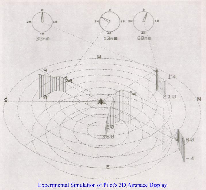
http://zoom.interoscitor.com/PetersonEnterprises/Consulting/...
I was asked to come up with a 3D display of the airspace around an aircraft for the pilot to use and which could replace the 2D displays used then. People were impressed, but decided it was impractical for a variety of reasons. You can't really tell where the aircraft are relative to each other and the ground without rotating the display (which means the pilot loses their orientation), and there are no altitude indicators and it's difficult to tell where each aircraft is relative to the others. (Which is why I added the vertical lines and ground tracks.) Also things get visually messy when several aircraft are close together, even if you use different colors (which doesn't work for the colorblind). For example, could you use this display to tell if a collision is imminent near ground level in proximity to an airport? The display does give you a high level sense of what is going on in the airspace; it may not have enough details to be of practical use to pilots and air traffic controllers. I'd suggest consulting with them to get feedback. Maybe this would be practical as a VR display? How did they solve this in the F-35 helmet display?
Note from the developer: I’m so glad that many of you like this app. I’m a solo dev, actively building between my 9-5 and raising a 9mo. Please follow along on X https://x.com/benlimner , or join the mailing list for updates/suggestions!
also "copy this view" does nothing (neither location nor any settings, gives just the bare link)