Live data from Hacker News

Bifurcation: The secret giant islands formed when rivers split

starkeycomics.com

11–20 of 38 posts

Re: Bifurcation: The secret giant islands formed when rivers split

#11
> The Missouri is the largest tributary of the Mississippi River, which flows into the Gulf of Mexico

He must mean longest. This chart[0] shows that the Ohio is by far the largest tributary of the Mississippi by volumetric flow, and also shows the Atchafalaya bifurcation. However, the wiki articles for the Missouri[1] and Ohio[2] show average discharges into the Mississippi of 87,520 cu ft/s and 281,000 cu ft/s, respectively. Not as great a difference as the first chart [0] shows, but still significantly different. Even more interesting, since the Missouri drainage basin is about 2.5x larger.

[0]https://en.wikipedia.org/wiki/Mississippi_River#/media/File:...

[1]https://en.wikipedia.org/wiki/Missouri_River

[2]https://en.wikipedia.org/wiki/Ohio_River

Re: Bifurcation: The secret giant islands formed when rivers split

#13
post #9

This is not to take away from the fun of investigating and identifying these ‘bifurcation islands’, but on the question of whether they qualify as ‘islands’: > Like a delta island, it is surrounded entirely by sea and rivers. As an area of land separate from a continent, permanently and entirely surrounded by water, it seems to fit every definition of an island I can find. I agree that by ‘Air Bud’ rules these qualif…

Presumably (with little more than an 8 y/o grasp of astronomy), Pluto’s orbit being consistent with the other heliocentric planets gave it an extra qualifier?

It’s not consistent with the other planets though. Mercury is off by 7 degrees, the other planets are within 3.

Pluto meanwhile is 17 degrees off the ecliptic so it’s a serious outer.

Re: Bifurcation: The secret giant islands formed when rivers split

#14

This is not to take away from the fun of investigating and identifying these ‘bifurcation islands’, but on the question of whether they qualify as ‘islands’: > Like a delta island, it is surrounded entirely by sea and rivers. As an area of land separate from a continent, permanently and entirely surrounded by water, it seems to fit every definition of an island I can find. I agree that by ‘Air Bud’ rules these qualif…

I resolve these things is by remembering that words are only approximate definitions of real world concepts.

This means there will always be a fuzzy area where it's not clear if the word covers it or not. I recommend not trying to determine exactly what the boundaries of the word are. Try using more/other words instead.

This may be an easier thing to internalize when you know more than one language.

Re: Bifurcation: The secret giant islands formed when rivers split

#15
post #6

Bifurcation occurs at the Great Lakes, where the Mississippi flows into the gulf and the St. Lawrence empties into the Atlantic. This forms the “great loop”, a circumnavigation course known by many power boaters . This makes about half of the United States and island by your definitions.

The Chicago - Great Lakes connection is man made, so doesn't count per the methodology of the OP.

Re: Bifurcation: The secret giant islands formed when rivers split

#16
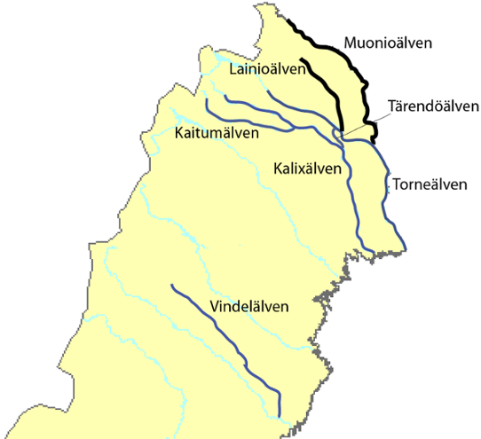
As a kid I found a bifurcation island in northern Sweden, that may be bigger than Gotland, the conventionally biggest island in Sweden.

It's formed by the Tärendö River which flows from the Torne river to Kalix river.

It's supposedly the second biggest bifurcation in the world: https://en.wikipedia.org/wiki/T%C3%A4rend%C3%B6_River

This is the best image I found: https://www.smhi.se/polopoly_fs/1.30940.1490013619!/image/%C...

Re: Bifurcation: The secret giant islands formed when rivers split

#17

This is not to take away from the fun of investigating and identifying these ‘bifurcation islands’, but on the question of whether they qualify as ‘islands’: > Like a delta island, it is surrounded entirely by sea and rivers. As an area of land separate from a continent, permanently and entirely surrounded by water, it seems to fit every definition of an island I can find. I agree that by ‘Air Bud’ rules these qualif…

[deleted]

Re: Bifurcation: The secret giant islands formed when rivers split

#18
post #6

Bifurcation occurs at the Great Lakes, where the Mississippi flows into the gulf and the St. Lawrence empties into the Atlantic. This forms the “great loop”, a circumnavigation course known by many power boaters . This makes about half of the United States and island by your definitions.

The Chicago - Great Lakes connection is man made, so doesn't count per the methodology of the OP.

So North and South America are not the North and South Panama Canal Islands. Got it!

Re: Bifurcation: The secret giant islands formed when rivers split

#19
I live near what used to be several of these - Kaiapoi Island,Coutts Island, McLeans Island, Templar Island, no doubt forgetting some.

Created by the Waimakariri River splitting into 3 branches as it neared the ocean.

They're no longer islands as the two side-branches of the river caused repeated severe floods in colonial days, so large civil engineering efforts went into restraining the river, ultimately leading to the south branch and north branch being blocked by large stopbanks and riprap cassions.

Both branches were then utilised to drain water from high fertility but swampy ground.

Because NZ's braided rivers lend themselves to wandering channels, we've still got some decent sized river islands - Rākaia Island, Rangitata Island.

Re: Bifurcation: The secret giant islands formed when rivers split

#20
post #3

The article that follows that one is also very interesting and worth reading. It shows how a coastline that existed 100 million years ago and cut through modern day Alabama is still visible in demographic and election maps. (By a crazy coincidence, I just dug up that article and sent it to someone not even half an hour ago, since we were talking about geology and I remembered reading it. Then I go to HN and see this…

Synchronicity
Post reply on HN