Chesapeake Bay Impact Crater
en.wikipedia.org
Chesapeake Bay Impact Crater
1–10 of 26 posts
Re: Chesapeake Bay Impact Crater
#2This may have contributed to the immiseration and decline of the Jamestown colony, some thirty-five million years later:
"Chesapeake Bay is the remains of a giant meteor crater. The impact shattered rock for miles, letting seawater infiltrate. Few Indian groups lived in the saltwater wedge, presumably for just that reason. Jamestown was bordered and undergirded by bad water. That bad water, the geographer Carville V. Earle argued, led to 'typhoid, dysentery, and perhaps salt poisoning.' By January 1608, eight months after landfall, only thirty-eight [of the original 144] English were left alive."
From Charles Mann's "1493", which is a fantastic read; it's full of satisfying connections between environmental and historical forces like the above.
Re: Chesapeake Bay Impact Crater
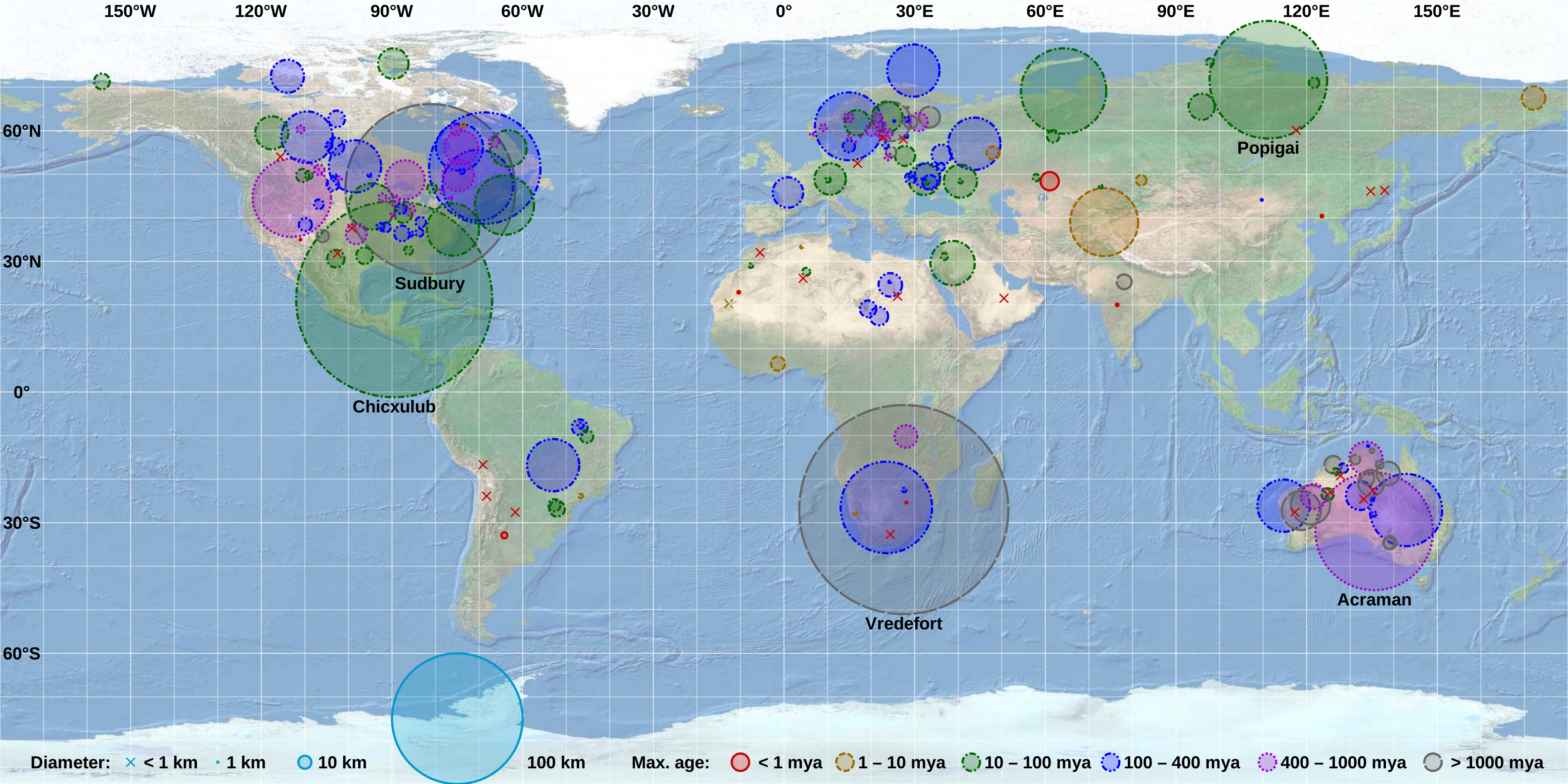
#3Looking at this map[1] of known impact craters, it looks like of the landmasses, eastern Canada, (western) Australia and northern Eurasia have experienced the most impacts and Africa, China and South America have experienced the fewest (Antarctica largely unknown).
Now one thing which the map doesn’t represent is the position (coöperdinates) of the affected landmass at time of impact.
[1]https://upload.wikimedia.org/wikipedia/commons/c/cc/Earth_Im...
Re: Chesapeake Bay Impact Crater
#4Looking at this map[1] of known impact craters, it looks like of the landmasses, eastern Canada, (western) Australia and northern Eurasia have experienced the most impacts and Africa, China and South America have experienced the fewest (Antarctica largely unknown). Now one thing which the map doesn’t represent is the position (coöperdinates) of the affected landmass at time of impact. [1] https://upload.wikimedia.org…
The results are affected by the density of geologists.
Re: Chesapeake Bay Impact Crater
#5Looking at this map[1] of known impact craters, it looks like of the landmasses, eastern Canada, (western) Australia and northern Eurasia have experienced the most impacts and Africa, China and South America have experienced the fewest (Antarctica largely unknown). Now one thing which the map doesn’t represent is the position (coöperdinates) of the affected landmass at time of impact. [1] https://upload.wikimedia.org…
The results are affected by the density of geologists.
Yep, just like dinosaur fossils.
Re: Chesapeake Bay Impact Crater
#6It amazes me that these events seem "frequent" when you look at them overall, but then extremely rare when you realise how far apart some of them are (millions and millions of years). It really makes you realise just how small a window of time human existence has been given. We may see one or two major geological events in all of human histroy if we're lucky (or unlucky, depending on what they are!).
Re: Chesapeake Bay Impact Crater
#7Looking at this map[1] of known impact craters, it looks like of the landmasses, eastern Canada, (western) Australia and northern Eurasia have experienced the most impacts and Africa, China and South America have experienced the fewest (Antarctica largely unknown). Now one thing which the map doesn’t represent is the position (coöperdinates) of the affected landmass at time of impact. [1] https://upload.wikimedia.org…
The results are affected by the density of geologists.
Africa, China and South America have wonderful geologists and people just like America and Europe. What are you trying to say?
Re: Chesapeake Bay Impact Crater
#8Earlier quoted context omitted.
The results are affected by the density of geologists.
Africa, China and South America have wonderful geologists and people just like America and Europe. What are you trying to say?
There have been more geologists per area in the places where lots of astroblemes have been found. It's a selection effect, not a real effect.
Re: Chesapeake Bay Impact Crater
#9Looking at this map[1] of known impact craters, it looks like of the landmasses, eastern Canada, (western) Australia and northern Eurasia have experienced the most impacts and Africa, China and South America have experienced the fewest (Antarctica largely unknown). Now one thing which the map doesn’t represent is the position (coöperdinates) of the affected landmass at time of impact. [1] https://upload.wikimedia.org…
I like that the Carancas impact event is listed as .000007 mya. I happened in 2007.
Re: Chesapeake Bay Impact Crater
#10Looking at this map[1] of known impact craters, it looks like of the landmasses, eastern Canada, (western) Australia and northern Eurasia have experienced the most impacts and Africa, China and South America have experienced the fewest (Antarctica largely unknown). Now one thing which the map doesn’t represent is the position (coöperdinates) of the affected landmass at time of impact. [1] https://upload.wikimedia.org…
Could be related to age of crust?