Live data from Hacker News

Google Maps is no longer a flat map

techcrunch.com

141–150 of 173 posts

Re: Google Maps is no longer a flat map

#141
post #136

Earlier quoted context omitted.

the author of TFA probably thought the desire for correct shape in a map is implied and wasn’t trying to defend against map pedantry. of what use is a map if the shapes are wrong?

One of the revolutions in the first Underground/Subway/Metro maps was that by throwing away the actual shapes, it is able to represent the stations and the relationships between them far clearer than otherwise.

a subway map has little to do with a geographic map. only the nodes and time traveled between them matter. the shape of the actual routes is immaterial.

Re: Google Maps is no longer a flat map

#142
post #31

Earlier quoted context omitted.

Australian maps are shown with Oz in the middle, and the pacific / indian oceas each side, with South East Asia and Antarctia surrounding, exactly the same way US maps put the US in the center.

Do you mean whole-world maps have Australia in the center? (I assume so, since obviously a map of only Australia would have Australia as the center...) That's fascinating! I grew up in the US and I'm not sure I've ever used a world map with the US in the center. Curious where you got this impression. I can find some examples if I specifically search online, but they look very weird to me. Every world map I grew up wi…

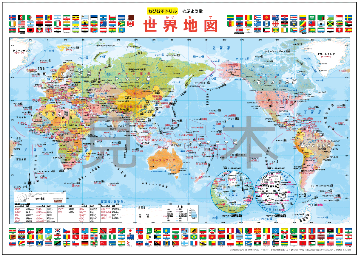
Maps in Japan have Japan and the Pacific ocean in the center and the Americas off to the right. Which make the phrases "the west" and "the east" kind of interesting choices.

Example of a map poster for kids: http://happylilac.net/sekaitizu-mihon.gif

Re: Google Maps is no longer a flat map

#143
post #78

Google Maps must be one of the modern wonders of the world, it's still nothing short of breathtaking to zoom out of streetview in crowded London and then land somewhere on a country crossroads in remote Vietnam.

I count with one hand all the technologies that have blown my mind: discovering the electronic parts of my toys, playing a NES game in my friend's PC, my first contact with the internet, the first iPhone. But discovering Google Earth was a really special one, suddenly I was able to explore every street in the world, I was able to look at my house (in a small city in a developing country). Then I started imagining all…

There was a guy on a TV documentary once that had worked for the government in some capacity. He was explaining that the satellite maps provided to the public are extremely zoomed out compared to what the government is able to see.

He said that the government had photography so detailed, that they could find a golf ball on a golf course, and even tell you what brand of golf ball it is.

Re: Google Maps is no longer a flat map

#144

Google Maps must be one of the modern wonders of the world, it's still nothing short of breathtaking to zoom out of streetview in crowded London and then land somewhere on a country crossroads in remote Vietnam.

It is, i remember being captivated by this film in the (mid? late?) 90s.. (from the late 70s, pieced together by hand). Never imagined it would be (partly) possible in realtime.. some 10 years later.

(eagerly hanging out for orbit view milky way, but probably not in my lifetime)

https://www.youtube.com/watch?v=0fKBhvDjuy0

Re: Google Maps is no longer a flat map

#145
post #143
post #78

Earlier quoted context omitted.

I count with one hand all the technologies that have blown my mind: discovering the electronic parts of my toys, playing a NES game in my friend's PC, my first contact with the internet, the first iPhone. But discovering Google Earth was a really special one, suddenly I was able to explore every street in the world, I was able to look at my house (in a small city in a developing country). Then I started imagining all…

There was a guy on a TV documentary once that had worked for the government in some capacity. He was explaining that the satellite maps provided to the public are extremely zoomed out compared to what the government is able to see. He said that the government had photography so detailed, that they could find a golf ball on a golf course, and even tell you what brand of golf ball it is.

There's always some dude on TV bragging, but I'd be skeptical.

https://www.quora.com/How-powerful-are-the-cameras-on-modern...

TL;DR is that satellites have a 9 cm resolution at best. That's not enough to see a golf ball (4 cm diameter), and far away from discovering a producer's imprint on it.

With drones you can get an order of magnitude better, but that's still only barely enough to find said golf ball, and not enough to read fine print.

Re: Google Maps is no longer a flat map

#146
post #110

Looks like this isn't rolled out to everyone. I'm not seeing the 3D version (logged in & incognito).

For rollouts like this, a small holdback experiment is typical, to assess long term trends. Or maybe your browser doesn't have hardware acceleration enabled? Or you could be in canvas mode? Try ?force=webgl on the end of the maps url in case it's the latter. Try shadertoy.com to see if webgl is available.

Webgl works on my browser. Shaders work. Google maps is still flat. force=webgl does nothing. I'd say it's a partial roll out.

Re: Google Maps is no longer a flat map

#147
post #143

Earlier quoted context omitted.

There was a guy on a TV documentary once that had worked for the government in some capacity. He was explaining that the satellite maps provided to the public are extremely zoomed out compared to what the government is able to see. He said that the government had photography so detailed, that they could find a golf ball on a golf course, and even tell you what brand of golf ball it is.

There's always some dude on TV bragging, but I'd be skeptical. https://www.quora.com/How-powerful-are-the-cameras-on-modern... TL;DR is that satellites have a 9 cm resolution at best. That's not enough to see a golf ball (4 cm diameter), and far away from discovering a producer's imprint on it. With drones you can get an order of magnitude better, but that's still only barely enough to find said golf ball, and not en…

Who said it has to a be a satellite?

Re: Google Maps is no longer a flat map

#148
post #137
post #130

While I was working on the PowerBI globe map visualization https://powerbi.microsoft.com/en-us/blog/visual-awesomeness-... (video in link) I had to do some funky magic to stitch square tiles in a sphere from bing maps and do reverse mercerator projection. I had to also ensure GPS coordinates would exactly align to the right pixel otherwise the 3D chart would all look weird. So there was a lot of fun math involved ove…

I'm interested in learning more! I imagined linear interpolation could work too. What went wrong?

This does a hemisphere but doesn’t map lng and lat. Gives an example of the kind of maths involved. https://math.stackexchange.com/questions/1334241/interpolate...

It’s not a simple linear x0, y0, z0 -> x1, y1, z1 because you kind of want an animation like a square blanket is wrapping around a ball, stretching the right amount in different places such that it becomes a sphere.

I tried to find a single magical equation that would give a x0, y0, 0 -> x1, y1, z1 based on param t that goes from 0 - 1. I’m sure there exists one but I tried all sorts of fancy math I knew for a day or two and still had major trouble writing it down as a single equation function.

Then I thought about it in a different way after I ate a fruit and realized I need an orange analogy. What if we cut slices of orange. The ends are crescent shapes. Now it’s a matter of animating the crescents into rectangular strips where the pointy ends stretches but the middle part remains the same.

Since in computer graphics, a sphere isn’t really a true sphere, but an approximation with triangles the strip analogy works well. We just need to animate the ends of triangles.

The gotcha is the pointy end of sphere expands from 0 to length of mercerator projection (flat square) so they cut a tiny bit of the top and bottom otherwise you have infinite stretching at the end

So you have three little functions. For an x,y in a square you figure out what slice they go into and what side of the slice. The further to the poles, the more you squeeze towards the center, so you get something like this https://blenderartists.org/t/producing-a-12-petal-gores-from...

Then you have a blanket wrapping function I.e morphing a line into circle and that’s a line -> arc -> circle animation. That’s not too hard. The arc of a very large circle is almost flat. So you divide the line into two and animate the left and right segments into two hemicircle arcs that then form a proper circle. Kind of like curving the lines from the end to bend it into a circle.

Now longitudes and latitudes both go through this line to circle animation. To get the z, we take the x arc position, the y arc position, the point on crescent strip and we do matrix rotate transforms to get final x,y,z

So rather than it being one single equation (which i’m guessing is possible using super crazy maths), we take a piecemeal approach and animate lots of little segments that add up as a plane to sphere animation using simpler maths and matrix transforms.
Re: Google Maps is no longer a flat map

#149
What's really interesting that in 2D maps, every country had their own variation of it.

If you were to take a 2D printed world map from America and compared it to a 2D printed world map, the sizes of continents wouldn't be the same, nor the centerpiece of the map itself. It would always center around that respective country first.

Re: Google Maps is no longer a flat map

#150
post #37

I wonder what the long term geopolitical consequences will be when we all stop looking at projected maps. That small peninsula to the west of Asia just got a little smaller. A certain island kingdom is now more clearly the size of Uganda. Maybe Google can also flip the globe "upside-down" for all users "below" the equator.

A generation growing up on this will probably be less likely to believe in a flat earth, since the intuition will develop from the time they first start looking at maps.

Globes (the good old physical item) exists since ~150 BC
Post reply on HN