I'd love to see comparisons between Manhatten and New York, or central Kyoto and Kyoto proper, as well as other old Asian capitals that were often based on a grid system, but might not have kept it outside "the old city"
City street orientations around the world
61–70 of 89 posts
Re: City street orientations around the world
#62Funnily enough I find organic street layouts easier to navigate as a tourist than grid systems. In an organic layout there are central roads that go to places of interest and the smaller streets flow to the central roads. In a grids all the roads look the same (they have the same size for example) so I often can't work out how I'm oriented and wandering around doesn't necessarily lead to anywhere interesting. I also…
Optimising for tourists is pretty lame, they don't have to live there. In my opinion, I think a balance between the approaches works well. I'm in Philadelphia. I really appreciate that anyone can tell me some event is at "14th and Locust" and I know how to get there without directions. At the same time, roads like Ben Franklin Parkway are wide and open enough, with multiple courtyards along its length, that it opens…
The reason I said "for tourists" is because a local will learn the layout eventually regardless of what it is. I don't think my experiences in, say, Birmingham where I lived for a decade are comparable to my experiences in Philly, which I have visited once for a few days.
Re: City street orientations around the world
#63The most remarkable city I’ve ever visited is Seville, Spain. It has a labyrinth of tiny streets and apparently no grid. As a pedestrian, I felt like I could get “lost” while never really being truly lost. In fact, I think I could still get around in Seville without a map if you dropped me into a random spot.
On the other hand, I live 90 minutes from Charlotte and have been there a dozen times and have absolutely no clue how to navigate that city. It’s a mess.
Re: City street orientations around the world
#64Really interesting. I suspect there's something about the political climate more than the age of the city that dictates the orientation of the roads. Where societies where strongly controlled by small group of leaders (religious leaders, monarchs, city planners, etc) the streets ended up much more coherent. Where cities grew organically as needed the layouts are less coherent. Also, what happened in Charlotte?!
I was curious about Charlotte as well, best I could find: ----- The streets of most newer American cities follow very clear East-West and North-South grid patterns, but not here. The streets of Charlotte have some of the most unusual patterns in the world. Our city may seem like a new city, but it actually has a very rich history of Native Americans, famous battles, and gold. We were founded in 1768 (and officially d…
Here's a map I made of Queens road in Charlotte.
https://danielvf-downloads.s3.amazonaws.com/2018/queens_road...
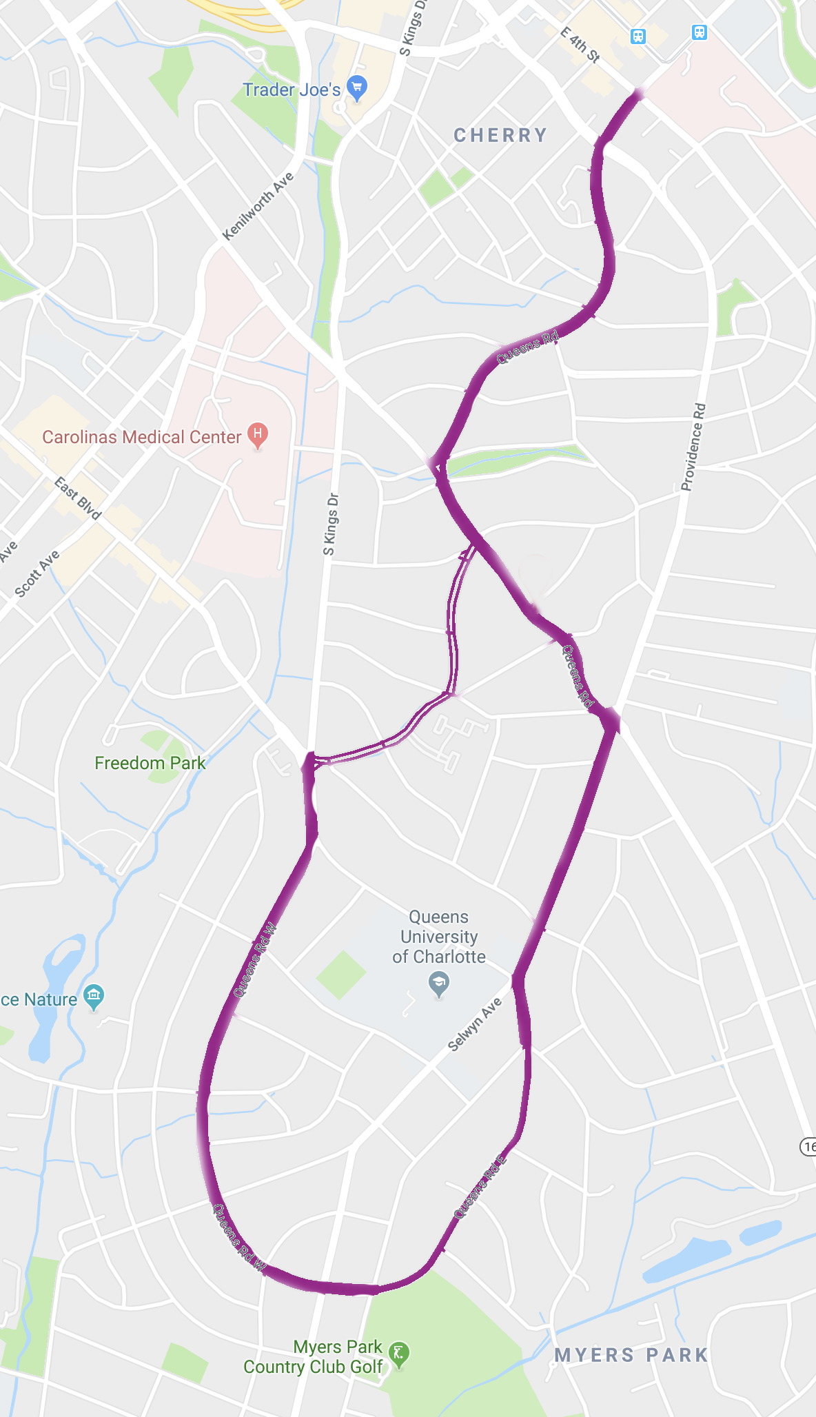
- In driving down five major roads, you can suddenly be on Queens road.
- It intersects itself.
- Following it requires making constant right or left turns at stop lights, or you end up on a different road.
Re: City street orientations around the world
#65Earlier quoted context omitted.
Optimising for tourists is pretty lame, they don't have to live there. In my opinion, I think a balance between the approaches works well. I'm in Philadelphia. I really appreciate that anyone can tell me some event is at "14th and Locust" and I know how to get there without directions. At the same time, roads like Ben Franklin Parkway are wide and open enough, with multiple courtyards along its length, that it opens…
The reason I said "for tourists" is because a local will learn the layout eventually regardless of what it is. I don't think my experiences in, say, Birmingham where I lived for a decade are comparable to my experiences in Philly, which I have visited once for a few days.
I've been local to Boston for decades and haven't truly learned the layout. I can get to any given place, but without consulting the map I'll often choose a suboptimal route. It's hard to stop my brain from forcing the layout into a grid, which it very much is not.
Re: City street orientations around the world
#66Can this visualization ever be non-symmetrical?
Like, a street that goes north tends to go south if you're headed in the other direction. Is it one-way streets that make Charlotte's visualization non-symmetrical?
Re: City street orientations around the world
#67Funnily enough I find organic street layouts easier to navigate as a tourist than grid systems. In an organic layout there are central roads that go to places of interest and the smaller streets flow to the central roads. In a grids all the roads look the same (they have the same size for example) so I often can't work out how I'm oriented and wandering around doesn't necessarily lead to anywhere interesting. I also…
Having grown up in a city with a very well defined grid, Chicago, I mainly favor grid layouts. Here you can tell important facts about a location based solely on the address. Given an address, like 4012 N Pulaski, I immediately know how far it is from me in the North/South direction and also in which direction on that axis. I also know it's on the West side of the street. The only other important bit not included is…
Yep, I recently learned that Daniel Burnham designed them that way. The Great Fire of 1871 cleared out legacy street systems, so things could start anew. The diagonal transporters like Ogden, Milwaukee etc. mess me up though.
Chicago grid
https://www.domu.com/blog/decoding-the-chicago-street-grid-s...
Re: City street orientations around the world
#68Houston's graph is oriented like +, but the downtown grid in Houston should be represented like x.
Re: City street orientations around the world
#69Earlier quoted context omitted.
Having grown up in a city with a very well defined grid, Chicago, I mainly favor grid layouts. Here you can tell important facts about a location based solely on the address. Given an address, like 4012 N Pulaski, I immediately know how far it is from me in the North/South direction and also in which direction on that axis. I also know it's on the West side of the street. The only other important bit not included is…
Yep, I recently learned that Daniel Burnham designed them that way. The Great Fire of 1871 cleared out legacy street systems, so things could start anew. The diagonal transporters like Ogden, Milwaukee etc. mess me up though. Chicago grid https://www.domu.com/blog/decoding-the-chicago-street-grid-s...
The diagonals can be a little confusing, especially since they're numbered as if they're North/South, but unlike a true North/South street they have no fixed East/West number (Lincoln is 1600 W at Ashland but 2000 W at Damen).
They always mess my wife up when she's driving as well (think easy right vs. hard right when approaching a three way intersection). What gets me is when driving on a diagonal and the intersecting streets bend right at the intersection so that they meet the diagonal at a 90 degree angle. That messes with my head because it feels like you're driving on one of the normal grid streets.
Re: City street orientations around the world
#70Funnily enough I find organic street layouts easier to navigate as a tourist than grid systems. In an organic layout there are central roads that go to places of interest and the smaller streets flow to the central roads. In a grids all the roads look the same (they have the same size for example) so I often can't work out how I'm oriented and wandering around doesn't necessarily lead to anywhere interesting. I also…
Yeah -- the original intent behind Manhattan's grid system was not some sort of usability or urbanist thought, but to "open up" the land for real estate speculation. See: https://en.wikipedia.org/wiki/Commissioners%27_Plan_of_1811