Live data from Hacker News

City street orientations around the world

geoffboeing.com

21–30 of 89 posts

Re: City street orientations around the world

#21
post #8

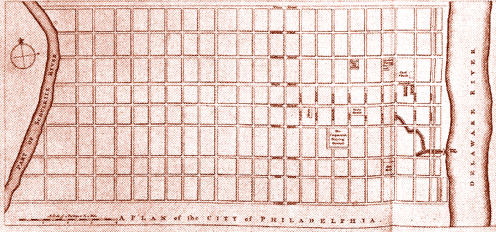
Anyone know why Philadelphia has a kinda NSEW orientation like the other cities but rotated ever so slightly? Manhattan is similar and it makes sense (they are aligned with the island itself), but Philadelphia is so close to the actual compass points and not aligned with anything really else.

The ~same offset appears in Penn's original plan.[0]

Maybe it was based on geomagnetic north? The magnetic declination in Philadelphia is now about -13 degrees, but it was maybe -8 degrees in 1682.[1]

0) http://www.ushistory.org/philadelphia/images/philadelphia1.g...
1) https://en.wikipedia.org/wiki/Magnetic_declination

Re: City street orientations around the world

#23

Funnily enough I find organic street layouts easier to navigate as a tourist than grid systems. In an organic layout there are central roads that go to places of interest and the smaller streets flow to the central roads. In a grids all the roads look the same (they have the same size for example) so I often can't work out how I'm oriented and wandering around doesn't necessarily lead to anywhere interesting. I also…

> In a grids all the roads look the same (they have the same size)

Does not have to be true and often is not true. Some places alternate alley (single lane, one way) with neighborhood (one lane each direction) and every ~4 neighborhood streets, have a larger street, either with wider lanes or more lanes.

Grid does not have to mean all streets look the same or be of equal weight.

Re: City street orientations around the world

#24
post #4

I grew up in the UK where most towns and cities have roads going in all directions. I've always found the grid layout of US cities difficult to navigate, which is strange because it's objectively a much simpler system. The sameness of each block and straightness of the roads makes it really hard for me to position myself with sight alone, whereas in the UK there seems to be more uniqueness to each road that makes it…

If you know a city somewhat, organic layouts can tend to channel you toward major squares/circles and other landmarks. London is a good example. On the other hand, it can be fairly easy to get totally turned around. Not that big a deal in an era where everyone has a GPS in their pocket but still.

That said, I'm not sure why someone would find the mostly grid layout of large sections of New York, for example, hard to navigate as a pedestrian. Yes, there are a lot of street crossings but a lot of that is a function of density and you can use the grid to go either up/down or cross-town depending on the lights and traffic. I find it's pretty convenient to more or less know where something is and how far away it is just based on an address/pair of cross-streets.

Re: City street orientations around the world

#25
This is very interesting! I wonder what the chart would look like if the lengths in each direction represented total lengths of streets in that orientation.

Hypothesis for some of the oldest European cities which look like big circles currently - the older parts of the cities which would likely have streets going in all directions are small - so the fat circles would get smaller and we'd start seeing spokes for the newer parts of the cities.

Re: City street orientations around the world

#26

How come there appears to be symmetry in Rio de Janeiro?

180 degree rotational symmetry happens because almost all roads are bidirectional -- if there's a road pointing north, it's also a road pointing south.

90 degree symmetry seems like a consequence of the road system consisting more of straightness and 90 degree turns, with no other specific angle being common.

https://www.google.com/maps/@-22.9111837,-43.2566471,14z

Rio fits the bill. There's no overarching grid, but if you zoom into any small area, you'll usually find a pattern of rectangular blocks with 90 degree intersections.

As far as I can see, the only viable way out rotational symmetry would be to use concentric 'ring-blocks' either for local areas or for the city as a whole. The rings would cancel themselves out, and the 'spokes' could be places relatively freely.

So... Canberra might have an interesting distribution?

https://www.google.com/maps/place/Canberra+ACT+2601/@-35.288...

Re: City street orientations around the world

#28
post #22
post #20

Earlier quoted context omitted.

Especially now that we all use navigation apps in our cars.

To be fair, even with navigation apps central London is a nightmare...

Like a lot of automated things, navigation apps are pretty much designed for the 95% case. Especially somewhere like a city, they fall down on the lack of instructions like "You want to be getting over into the right hand lane soon. You'll be making a turn up at $LANDMARK in a couple of minutes." Or, in London, which of the 5 streets coming off the circle do you want to be taking exactly?

Re: City street orientations around the world

#29
post #15

Earlier quoted context omitted.

As a European, I agree. US cities are confusing to me because streets all look the same. I find it impossible to locate interesting areas without prior knowledge. Maybe what seems easiest to navigate depends on what you’re used to?

I think so. My US colleagues seem to find it very easy to get around unfamiliar US cities but seem to struggle in European cities. I expect we have very different unconscious navigation algorithms.

I am from London and lived in the US for a bit. I struggled to navigate. I think it is because I navigate by modelling the shape of the streets. When all the streets are the same shape, that subconscious system stops working.

I also tend to find I underestimate distances in grid systems. I think it’s because in European cities I estimate distance by the number of distinct shapes I can remember on the way there. In a grid, I think my brain smushes all those identical block shapes into one. In a similar way to how time flies when doing a repetitive task.

Re: City street orientations around the world

#30
post #15

Funnily enough I find organic street layouts easier to navigate as a tourist than grid systems. In an organic layout there are central roads that go to places of interest and the smaller streets flow to the central roads. In a grids all the roads look the same (they have the same size for example) so I often can't work out how I'm oriented and wandering around doesn't necessarily lead to anywhere interesting. I also…

As a European, I agree. US cities are confusing to me because streets all look the same. I find it impossible to locate interesting areas without prior knowledge. Maybe what seems easiest to navigate depends on what you’re used to?

Ironically enough it appears to be very much in contrast with imperial (US) vs metric (EU, generally).
Post reply on HN