Open-Source Clojure Library for Geospatial Information
blog.factual.com
Open-Source Clojure Library for Geospatial Information
1–8 of 8 posts
Re: Open-Source Clojure Library for Geospatial Information
#2This is great news and I applaud the work. The state of open source for geospatial geometry has frequently been fragmented and dodgy at best so this effort to unify it are a step forward. PostGIS is the crown jewel of open source for GIS processing but a broader set of tools is much needed.
The only caveat looking at this is that the geometry computation is not suitable for some types of geospatial analytics. This has been a persistent gap in open source geospatial tools. The challenge is that closing this gap is a pretty esoteric topic in applied mathematics that only a handful of people are really qualified to address and few of them seem to be contributing to open source. Still, any progress is good.
Re: Open-Source Clojure Library for Geospatial Information
#3This is great news and I applaud the work. The state of open source for geospatial geometry has frequently been fragmented and dodgy at best so this effort to unify it are a step forward. PostGIS is the crown jewel of open source for GIS processing but a broader set of tools is much needed. The only caveat looking at this is that the geometry computation is not suitable for some types of geospatial analytics. This ha…
Can you expand on what the esoteric topic is and its application?
Re: Open-Source Clojure Library for Geospatial Information
#4This is great news and I applaud the work. The state of open source for geospatial geometry has frequently been fragmented and dodgy at best so this effort to unify it are a step forward. PostGIS is the crown jewel of open source for GIS processing but a broader set of tools is much needed. The only caveat looking at this is that the geometry computation is not suitable for some types of geospatial analytics. This ha…
Can you expand on what the esoteric topic is and its application?
Translating between coordinate systems and basically anything that involves mapping and measuring in 3 dimensions on an irregular not-quite-spherical surface is really hard to get right.
Re: Open-Source Clojure Library for Geospatial Information
#5Earlier quoted context omitted.
Can you expand on what the esoteric topic is and its application?
Translating between coordinate systems and basically anything that involves mapping and measuring in 3 dimensions on an irregular not-quite-spherical surface is really hard to get right.
I didn't make this picture, but it gives a good idea on the "irregular not-quite-spherical surface" part.
http://alienspacesciencenews.files.wordpress.com/2013/10/an-...
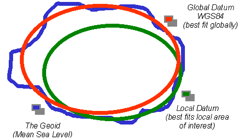
The Local Datum could be NAD83 or what-have-you based on where you are on the surface. Using the local datum gives better distance measurements and more accurately can represent elevation.
Re: Open-Source Clojure Library for Geospatial Information
#6This is excellent news. Without knowing much clojure or looking deeply into the source, I wonder if or how this project does or plans to handle projections and coordinate systems? I find this capability to be among the really important things that geospatial libraries provide.
Re: Open-Source Clojure Library for Geospatial Information
#7Earlier quoted context omitted.
Translating between coordinate systems and basically anything that involves mapping and measuring in 3 dimensions on an irregular not-quite-spherical surface is really hard to get right.
I didn't make this picture, but it gives a good idea on the "irregular not-quite-spherical surface" part. http://alienspacesciencenews.files.wordpress.com/2013/10/an-... The Local Datum could be NAD83 or what-have-you based on where you are on the surface. Using the local datum gives better distance measurements and more accurately can represent elevation.
That's a pretty great image. I'll have to remember it for next time someone asks why is all this so hard and can't we just use WGS84 for everything.
Re: Open-Source Clojure Library for Geospatial Information
#8For those that don't recognize the name on the blog post, this is aphyr, who has been publishing the excellent "call me maybe" technical posts.