Live data from Hacker News

The rectangularness of countries

pappubahry.com

61–70 of 150 posts

Re: The rectangularness of countries

#61
post #53

Earlier quoted context omitted.

What do they say?

Long, straight lines for borders usually imply that the territory through which they are drawn was neither well explored nor terribly important to the people drawing them. Sometimes that's because the territory is mostly uninhabited and nobody really has a strong claim to want their particular patch of land to be on one side or the other, but frequently its because the mapmakers either don't know or don't care about…

Exactly. Assuming that countries are united on the basis of some common characteristic (language/culture), the likelihood of this unity following a particular longitude or latitude (both European creations) with such mathematical precision is quite small. Straight borders are not exactly prevalent in Central Africa but the existing borders do not make sense in the slightest, and the dysfunction you see is largely a legacy of European meddling in the region.

Speaking of West Africa, you don't really have to think hard to figure out why Gambia's borders were drawn the way they were.
Re: The rectangularness of countries

#62
post #38
post #27

Earlier quoted context omitted.

There's a couple of different scoring rules that would be interesting, I think. Another one might be: What's the ratio between the area of the country and the smallest rectangle which bounds the country. This would "punish" countries with protuberances more than ones with "in-cuts", which "feels right" to me.

For some reason, your use of "'punish' countries" made me imagine a world where improving this score gets taken seriously by the peoples of the world, leading to countries gradually becoming more rectangular over time, and many terrible wars along the way.

Alternatively, an era of peace and cultural exchange as countries agree to swap territories to become more rectangular, leading to an influx of new immigrants to both countries and greater understanding that this cultural mixing brings.

But yeah, probably bloodshed and war.

Re: The rectangularness of countries

#63
These are not rectangles though. The projection has severly stretched many of the countries. Combined with the tilted angles, that should mean the corners of these "rectangles" aren't really 90°.

Re: The rectangularness of countries

#64
post #53

Earlier quoted context omitted.

What do they say?

Long, straight lines for borders usually imply that the territory through which they are drawn was neither well explored nor terribly important to the people drawing them. Sometimes that's because the territory is mostly uninhabited and nobody really has a strong claim to want their particular patch of land to be on one side or the other, but frequently its because the mapmakers either don't know or don't care about…

How does this reasoning apply to the US-Canada border?

Re: The rectangularness of countries

#65

I'm surprised Portugal didn't score higher. One day in the car I randomly asked myself the same question of "which country is the most rectangular", and Portugal was the first one I thought of. Is it because the Azores were included? Would like to see the rank if they had only the mainland.

Including Azores definitely affected the final result. It's weird that other countries didn't have their islands include though

Re: The rectangularness of countries

#66
post #53

Earlier quoted context omitted.

Long, straight lines for borders usually imply that the territory through which they are drawn was neither well explored nor terribly important to the people drawing them. Sometimes that's because the territory is mostly uninhabited and nobody really has a strong claim to want their particular patch of land to be on one side or the other, but frequently its because the mapmakers either don't know or don't care about…

How does this reasoning apply to the US-Canada border?

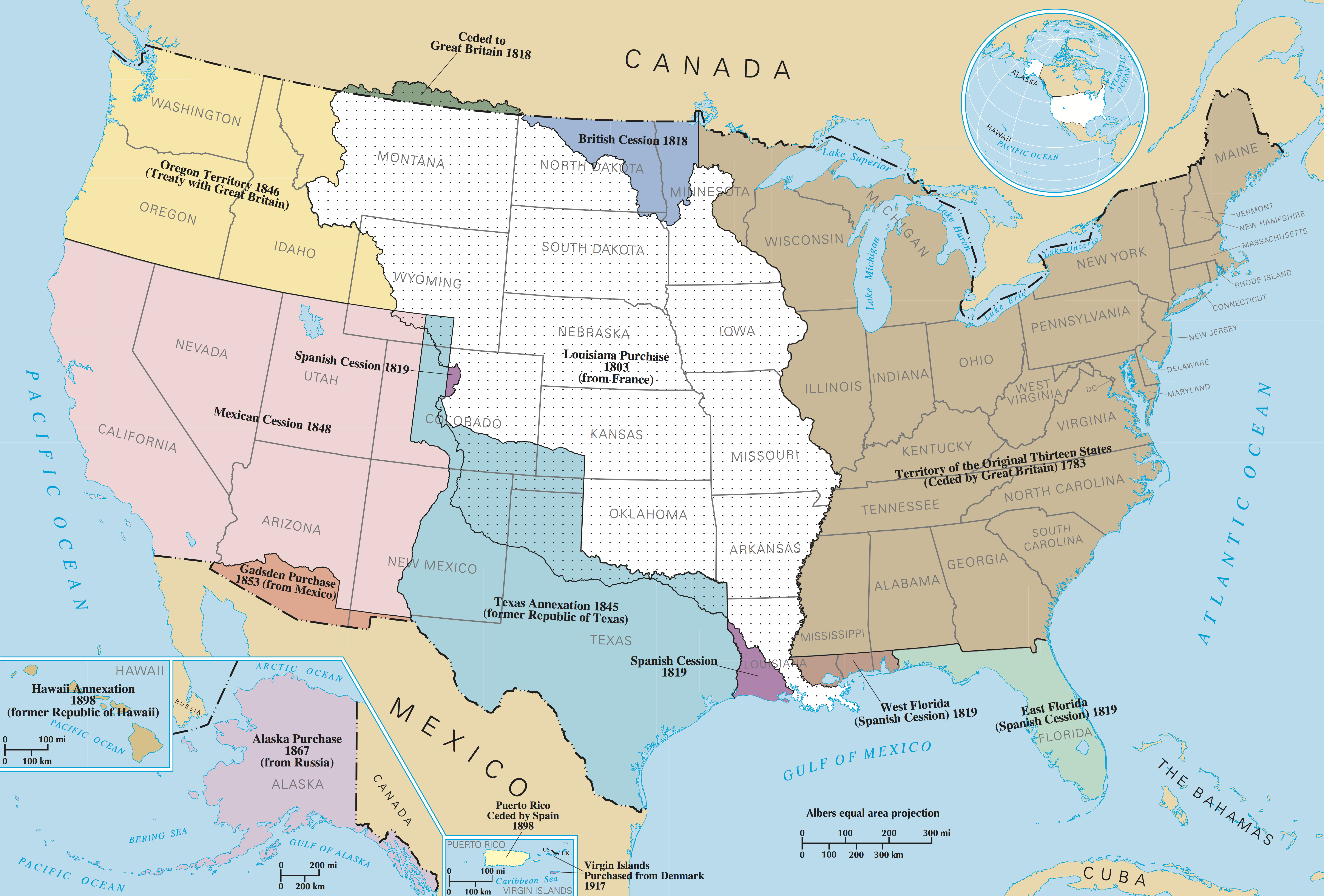
It applies perfectly. The 49° N section of the border was set in the Treaty of 1818 [1], at which point all affected regions were still populated by native americans.

You can see on this territorial expansion map [2] of the United States, how the lay of the border differs between the first-settled east and the later-settled west.

[1] https://en.wikipedia.org/wiki/Treaty_of_1818

[2] https://upload.wikimedia.org/wikipedia/commons/2/29/UnitedSt...

Re: The rectangularness of countries

#67
post #26

It's a good metric, but I do feel there's something slightly different being said in human terms when we say a country is "rectangular." Turkey seems to have sharper, closer to 90 degree angles than other countries that may overlap a rectangle more. I suspect what's really going on, psychologically, is that Turkey looks much more like a rectangle than it does any other basic shape: I would never described Macedonia a…

right. Côte d'Ivoire in particular has a very high score while "looking" nothing like a rectangle

Re: The rectangularness of countries

#68

I'm surprised Portugal didn't score higher. One day in the car I randomly asked myself the same question of "which country is the most rectangular", and Portugal was the first one I thought of. Is it because the Azores were included? Would like to see the rank if they had only the mainland.

Including Azores definitely affected the final result. It's weird that other countries didn't have their islands include though

Others are also affected by islands and territories, see France with French Guyana etc, Norway with Svalbard etc. France is quite a square country if you only consider its mainland so it is an odd choice to include non mainland areas but I guess it is a difficult greyzone on what to include and not.

Re: The rectangularness of countries

#69
post #53

Earlier quoted context omitted.

What do they say?

Long, straight lines for borders usually imply that the territory through which they are drawn was neither well explored nor terribly important to the people drawing them. Sometimes that's because the territory is mostly uninhabited and nobody really has a strong claim to want their particular patch of land to be on one side or the other, but frequently its because the mapmakers either don't know or don't care about…

To add a bit more, if you zoom a bit, there almost always will be some weird straight lines throughout the borders of a country. There are many towns in Turkey, for example, half of which went to Syria. I guess because no one from the people who came up with the borders knew the town was there and/or cared enough. There is even a Turkish movie about this: http://www.imdb.com/title/tt0216986/

Re: The rectangularness of countries

#70

I'm surprised Portugal didn't score higher. One day in the car I randomly asked myself the same question of "which country is the most rectangular", and Portugal was the first one I thought of. Is it because the Azores were included? Would like to see the rank if they had only the mainland.

My exact thought. But I'm Portuguese, so I'm biased.

Campeões!! Campeões!! Nós somos campeões!!
Post reply on HN