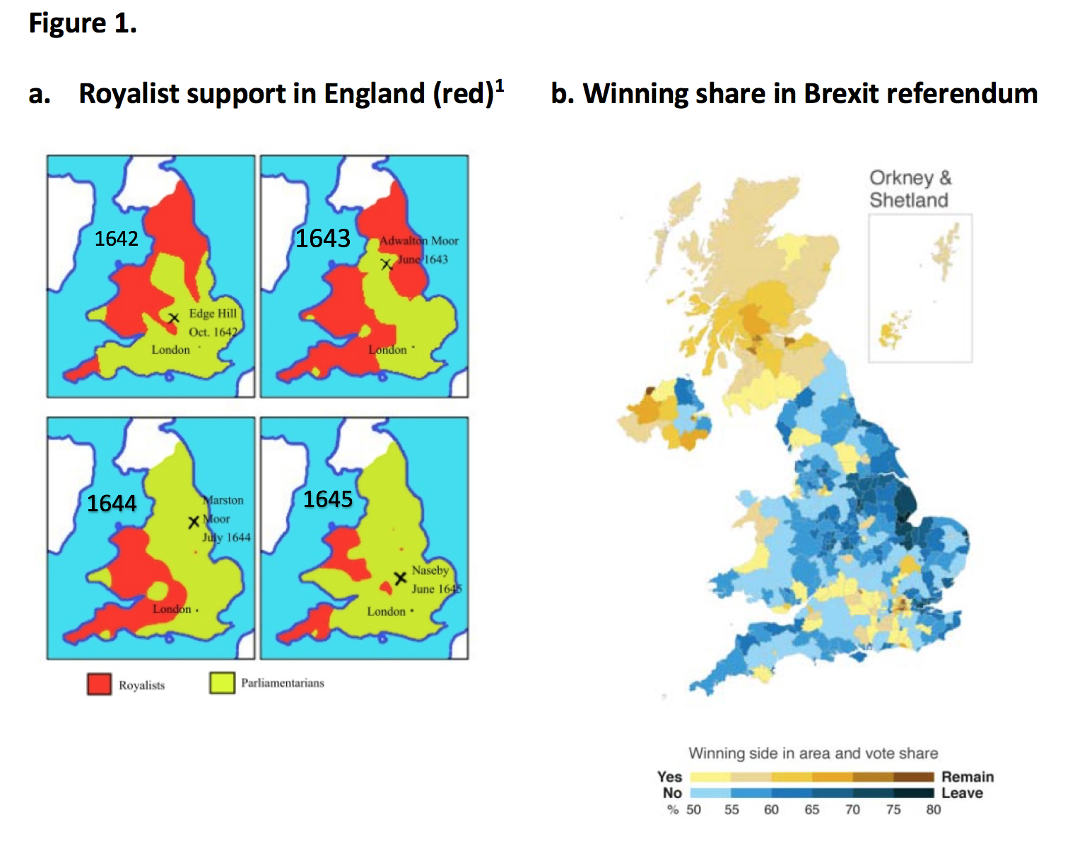
I thought that "political maps" simply meant sovereign state borders (as it does in Czech, German, and possibly other languages as well), and that this would be about unchanging borders. For example Bohemia has had some pretty stable natural borders. But in this case "political map" means a map of election results? Is that a common usage in English?
When old historic maps overlap with modern political maps
51–60 of 182 posts
Re: When old historic maps overlap with modern political maps
#52Peeve: To cause to be annoyed or resentful. synonym: annoy. These are not pet peeves at all, they are the persons pet loves. All examples are a type of "look at this great example, designed not to annoy or cause resentment at all, just the opposite! Aren't they cool and amazing?"
I studied French for four years and I'm sure there are all kinds of things that I say in that language that would confuse native French speakers as much as François Valentin confused us with an errant use of "pet peeve". I think he probably meant to say, "pet projects".
Re: When old historic maps overlap with modern political maps
#53I thought that "political maps" simply meant sovereign state borders (as it does in Czech, German, and possibly other languages as well), and that this would be about unchanging borders. For example Bohemia has had some pretty stable natural borders. But in this case "political map" means a map of election results? Is that a common usage in English?
Re: When old historic maps overlap with modern political maps
#54Peeve: To cause to be annoyed or resentful. synonym: annoy. These are not pet peeves at all, they are the persons pet loves. All examples are a type of "look at this great example, designed not to annoy or cause resentment at all, just the opposite! Aren't they cool and amazing?"
Re: When old historic maps overlap with modern political maps
#55I’m sceptical, it’s too easy to cherry-pick data to make it look supportive of one’s political agenda. Not saying it’s the case here, I just wouldn’t trust too much "obvious" patterns and easy to understand maps from a twitter thread. More often than not, such threads are omitting data that doesn’t support the view of the author. Reality is rarely obvious and simple.
Re: When old historic maps overlap with modern political maps
#56This seems to be complete BS to me: all I see in these maps is a lot of confirmation bias, the author really sees what he wants to see. Some maps do overlap very well but in that case it only looks interesting because we want to see a causation link where there is correlation. So sorry for the harsh words but I actually find this upsetting.
I completely understand your point. Misinterpreting correlation with causation is something that frequently bothers me in writings and discussions. In this case, however, I did find the correlations the author pointed out interesting. I did not interpret this as causal (the author may have made that claim, but I was more interested in the maps). I still found it really cool to see how much an impact geography and pat…
Think about the countless numbers of ways you could overlay any sort of historical map over some map representing any kind of relevant statistic. A smaller but still countless number of them will have strong correlations by pure chance alone. This is a simple fact of statistics.
The author here is filtering out exactly those that happen to have those kinds of correlations backed by some preconceived ideas the author has about how the causality is supposed to work and uses them to fuel his hypotheses, while ignoring the uncountable number of map overlays that don't show these correlations.
This is bog standard selection bias.
Re: When old historic maps overlap with modern political maps
#57Re: When old historic maps overlap with modern political maps
#58Peeve: To cause to be annoyed or resentful. synonym: annoy. These are not pet peeves at all, they are the persons pet loves. All examples are a type of "look at this great example, designed not to annoy or cause resentment at all, just the opposite! Aren't they cool and amazing?"
Re: When old historic maps overlap with modern political maps
#59Re: When old historic maps overlap with modern political maps
#60This seems to be complete BS to me: all I see in these maps is a lot of confirmation bias, the author really sees what he wants to see. Some maps do overlap very well but in that case it only looks interesting because we want to see a causation link where there is correlation. So sorry for the harsh words but I actually find this upsetting.
Sure, you could probably pick arbitrary political boundaries from different times and create maps that show the opposite trend. However, I would be surprised if there weren't correlative or causal factors, given that historical people reproduced and, in the case of many agrarian peoples, didn't migrate. It's possible that our collective ignorance of history makes this appear to be a novel fact, when we shouldn't be too surprised.