This is going to be a great enhancement. The maps in Wikipedia articles always seemed very lacking to me.
Wikimedia Maps Beta
51–60 of 84 posts
Re: Wikimedia Maps Beta
#52Nice effort, but still needs a lot of work. This view of the western US picks out four coastal cities worthy of mention: "Tijuana" (fine), "Los Angele" (sic!), "San Jose" (err..) and "Calgary" (wat). No San Francisco, no Seattle, no Vancouver... https://maps.wikimedia.org/#4/40.15/-93.38 Scripts are also all over the place. Japan is Japanese only, China is Chinese only, India is English, Bangladesh is Bengali, Pakist…
If you're going on population, San Jose is the biggest city in the Bay Area; in that sense, it makes sense to pick it as the "one that wins" in a very dense area. Calgary is around 1M people and Tijuana is 1.3M, while Seattle and Vancouver are each around 600k. Those choices seem pretty reasonable to me.
In the context of a zoomed out global map it would seem to make more sense to approach it by Metro area. Vancouver metro area is 2.5M vs Calgary's 1.2M. Seattle is 3.6M
Also, I would think national capitals should be included where possible.
Alas, it's an early beta.
Re: Wikimedia Maps Beta
#53Crimean names are in Russian. :/
Re: Wikimedia Maps Beta
#54Earlier quoted context omitted.
This is probably not intentional - the data is from OpenStreetMap, and if you have a look at http://www.openstreetmap.org/ you'll see that there isn't an attempt to make all labels the same language.
OSM has a policy that the base 'name' tag should be the name used on-the-ground locally, i.e. what appears in real life on street signs, building nameplates, and so on. Plus some special considerations for multilingual areas [1]. Items can also have additional language-specific tags (name:ja, name:en, etc.), which can in principle be used by renderers to display names in the language preference of the user, e.g. to p…
I wasn't aware of that policy - thanks for noting it.
Re: Wikimedia Maps Beta
#55Earlier quoted context omitted.
It's optional I suppose. I'm not aware of any official city documents that use it, but it has historical roots. > California Governor Felipe de Neve established the first civilian town or pueblo in California on November 29, 1777. Founded near the southern end of San Francisco Bay, it was christened El Pueblo de San José de Guadalupe. [1] http://web.archive.org/web/20080218051828/http://www.califor...
The official website seems to use the accent when the city name's is written in regular running text, but not when it's in all-caps or small-caps (as in the logo): http://www.sanjoseca.gov/
That used to be an unofficial convention of the Spanish language regarding accented letters: only in minuscule text but not on majuscule (capital) text. The Royal Academy has always supported (since at least 1792) that majuscules should be accented, but it was difficult to do so since movable types and typewriters didn't allow room for them: https://upload.wikimedia.org/wikipedia/commons/8/82/Acento_e...

Re: Wikimedia Maps Beta
#56I have tried one or two Google Maps mashups, but never bothered seriously because its ... Well not worth the effort learning on my free time how to use something that is not free. But openstreetmap and Wikipedia - how can I resist. Ok folks, let's look at this properly - you are going to get my donation this time round, and in five years google will look worried and in ten the goto mapping solution will be a free Wik…
I wonder if they're going to funnel contributions back to OSM.
They're not inviting separate contributions. There's no edit tab. If you want to edit these maps, you need to edit OSM.
Re: Wikimedia Maps Beta
#57The colour scheme is far more legible than open street map. I wish they'd change their styling...
Re: Wikimedia Maps Beta
#58Re: Wikimedia Maps Beta
#59One thing I found neat about this was that (at least by default) it seems language-neutral: scrolling around the world, labels over the U.S. are in English, labels in Japan are in Japanese, Korea, in Korean, China, in simplified Chinese, etc. Not even any romanized (or otherwise translated/transliterated) labels in parentheses. Just the native presentation. Granted that for practicality, you probably also want a mode…
Wikipedia comes in many languages, so ultimately they require the mapping system to display labels based on the language of the user.
This can be complicated - imagine a wiki page about Paris France, translated into 40 or so languages each with their own high performant, cached map served from the same system. Wikimedia maps will be beyond awesome in a few years!
Re: Wikimedia Maps Beta
#60Nice effort, but still needs a lot of work. This view of the western US picks out four coastal cities worthy of mention: "Tijuana" (fine), "Los Angele" (sic!), "San Jose" (err..) and "Calgary" (wat). No San Francisco, no Seattle, no Vancouver... https://maps.wikimedia.org/#4/40.15/-93.38 Scripts are also all over the place. Japan is Japanese only, China is Chinese only, India is English, Bangladesh is Bengali, Pakist…
Seems worth noting, it does have the right name for Los Angeles — the label is just running into Phoenix.
Looks like a boundary between tiles there:
https://maps.wikimedia.org/osm-intl/4/2/6.png
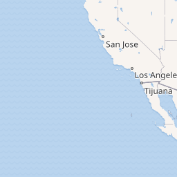
https://maps.wikimedia.org/osm-intl/4/3/6.png

Placing labels on a map is quite a hard problem, especially when certain tiles are refreshed.