> To make matters even more exciting, the last two coordinates might not be what you'd expect; when absolutely positioning items in CSS, right and bottom indicate the distance from the right and bottom edges respectively. In image maps, this holds no water. Instead, both horizontal coordinates are counted from the left edge and vertical coordinates from the top edge. Interesting. This order is commonly used by librar…
It's 2020 and I'm using image maps
41–50 of 109 posts
Re: It's 2020 and I'm using image maps
#42Re: It's 2020 and I'm using image maps
#43I still use tables for layouting because divs and messing with positioning/floating never really clicked for me.
Nothing wrong really. Tables used to sucks in IE era. But now IE is gone. Modern HTML Tables are fine as long as you know its limitations or basically dont try to do any fancy thing with it. For some strange reason I see people keep saying aviod table at all cost. I dont get it. May be someone could explain it better.
Tables are not the correct markup for positioning various items here and there to create a layout on a page.
Re: It's 2020 and I'm using image maps
#44[1] https://css-tricks.com/lodge/svg/31-can-put-raster-images-sv...
Re: It's 2020 and I'm using image maps
#45I feel like canvas tag plus image maps work really well together
With more of our traditional desktop services having moved to mobile and now moving back to the browser, I'm more concerned about this creating another wave of accessibility limitations caused by a petty convenience for dev.
I don't want to sound off like an activist, but I'd like to see that someone with limited mobility or sight can equitably access services they, as much as we, will sooner or later have to depend on as current apps and software lose support and phase out. The Net has always been a place where a person's only limitation should be their choice to not commit their time to learning how to use it. Let's stand by that now more than ever, or I fear we'll hand an uncontested victory to the idiots in Silicon Valley who want us to adapt to how they want us to use the Net.
Re: It's 2020 and I'm using image maps
#46Will this ever happen? We won't stop having radically differently sized devices any time soon. Of course I'm sure eventually the "responsive" approach will give way to other techniques but I can't really see the high-level approach disappearing.
Re: It's 2020 and I'm using image maps
#47> To make matters even more exciting, the last two coordinates might not be what you'd expect; when absolutely positioning items in CSS, right and bottom indicate the distance from the right and bottom edges respectively. In image maps, this holds no water. Instead, both horizontal coordinates are counted from the left edge and vertical coordinates from the top edge. Interesting. This order is commonly used by librar…
Interesting to perhaps no one else but those others that have suffered with it, the PDF specification allows drawing rectangles and other in-line graphical elements inside a 'sort of' canvas from a bottom right co-ordinate space only. I wondered for a while why that was.
Re: It's 2020 and I'm using image maps
#48The author seems to be have written this post based on work for an in-browser video editor ( https://videoinu.com/editor ). It runs completely on the client-side, so all the editing, previewing, rendering, and exporting is done using web technologies. Of course, it's not comparable to a professional editing tools but nevertheless that's very impressive achievement in my opinion!
If so, why just not use native desktop/mobile video editor app instead?
Re: It's 2020 and I'm using image maps
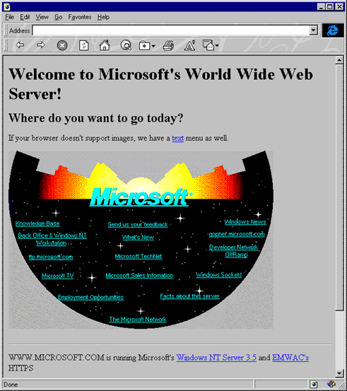
#49https://www.versionmuseum.com/images/websites/microsoft-webs...
Re: It's 2020 and I'm using image maps
#50> To make matters even more exciting, the last two coordinates might not be what you'd expect; when absolutely positioning items in CSS, right and bottom indicate the distance from the right and bottom edges respectively. In image maps, this holds no water. Instead, both horizontal coordinates are counted from the left edge and vertical coordinates from the top edge. Interesting. This order is commonly used by librar…
They're x, y pairs for the top-left and bottom-right corners of the rectangle. They're coordinates in the fourth quadrant of the Cartesian plane (i.e., with the origin conceptually in the top-left corner), which is also the way coordinates are given in most windowing systems (including X). This is more obvious when using the "poly" attribute rather than "rect," where you can have an arbitrary number of x, y pairs (an…