Live data from Hacker News

Who Needs GPS? The Story of Etak's 1985 Car Navigation System

fastcompany.com

21–30 of 88 posts

Re: Who Needs GPS? The Story of Etak's 1985 Car Navigation System

#21
post #9

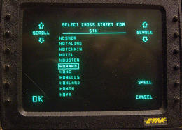
I saw Etak back in its early days, and Stan Honey gave me a demo. I still have one of their rate gyro/2D level units, and a compass unit. There's a motor driving a spinning disk, which warps slightly when the unit is turned, and sensors to detect the warp. The level, for sensing which way is down, is a sealed cup of liquid with the liquid height sensed with four capacitor plates outside the cup. The liquid was propri…

> about 20% of the population could not cope with a map that wasn't aligned with the direction they were going That's me. I have a tough time orienting maps in my head. I still use a mnemonic for compass directions and (occasionally) use my left hand as an L to make sure I'm not screwing it up. I don't know if there is any research into what the structural differences of brains that suffer from this might be, let alo…

    > I don't know if there is any research into [needing to
    > reorient maps when driving].
There is! One thing it's highly correlated with is whether you're either a heterosexual woman, or a homosexual man.

There's a really good description of this and other brain attributes correlated with gender or male homosexuality in the BBC show "The Making of Me - John Barrowman". This specific part starts around 6m30s in: http://www.dailymotion.com/video/x6a063_the-making-of-me-joh...

Here's an article about it in New Scientist, "Gay men read maps like women": https://www.newscientist.com/article/dn7069-gay-men-read-map...

That's not to suggest that you're either a homosexual man or a heterosexual woman based on this datapoint alone. There's of course plenty of people who don't fall into those groups who prefer to read maps that way, just to answer your question about whether there's research about it. Yeah, there's at least some research showing that spatial recognition is indicative of gender & sexual orientation.
Re: Who Needs GPS? The Story of Etak's 1985 Car Navigation System

#22
post #9

I saw Etak back in its early days, and Stan Honey gave me a demo. I still have one of their rate gyro/2D level units, and a compass unit. There's a motor driving a spinning disk, which warps slightly when the unit is turned, and sensors to detect the warp. The level, for sensing which way is down, is a sealed cup of liquid with the liquid height sensed with four capacitor plates outside the cup. The liquid was propri…

> about 20% of the population could not cope with a map that wasn't aligned with the direction they were going That's me. I have a tough time orienting maps in my head. I still use a mnemonic for compass directions and (occasionally) use my left hand as an L to make sure I'm not screwing it up. I don't know if there is any research into what the structural differences of brains that suffer from this might be, let alo…

I have a problem with directions / general spatial awareness that sounds similar to what you have. I have a hard time plotting a route to a known location in my head in the city I've lived in for 10+ years, but strangely have no problem getting there once I start driving/biking/walking (depending on how familiar I am with the destination, obviously). I've made it a point to study maps and randomly test whether or not I can point out cardinal directions when I'm out and about and that seems to have helped a bit, but I have a hard time navigating new and unfamiliar places. Truly big cities like Chicago are impossible to navigate. I don't know what I'd do without GPS.

Re: Who Needs GPS? The Story of Etak's 1985 Car Navigation System

#24
post #2

Interesting to read about alternative, non-centralized, forms of navigation. I wish modern cars which already have all the necessary sensors would use this method as a fallback, since GPS reception is not always available.

Every single mapping app has to implement some kind of mapmatching, since you can't rely on the GPS sensors to always be accurate: the GPS position is frequently wrong when you're moving between cell towers , and can be lost for several seconds in cities. Nokia/HERE's implementation (which I was told was very similar to tomtom/garmin's implementation) was written more than a decade ago, and IIRC, every time it encounters a fork in your path, it projects your position on every alternate for a few seconds and chooses the one that best matches the current gps+compass+accelerometer data as your "current" route. The output of this algorithm (which btw is hideously incomprehensible -- I'm talking old c++ with almost no comments) is what is used for map viewing/routing/guidance... the pure gps signal is never used as-is.

Re: Who Needs GPS? The Story of Etak's 1985 Car Navigation System

#25
post #8
post #2

Interesting to read about alternative, non-centralized, forms of navigation. I wish modern cars which already have all the necessary sensors would use this method as a fallback, since GPS reception is not always available.

Vehicle speed and steering position are available through OBDII. And inexpensive Bluetooth OBDII interfaces are available. But I don't think that navigation app developers have done anything to take advantage of that data for dead reckoning input. http://www.plxdevices.com/category-s/195.htm

I believe Apple requires CarPlay radios to provide wheel speed and compass readings (along with GPS) to the iPhone, and it gets used by CoreLocation to report location to apps.

Re: Who Needs GPS? The Story of Etak's 1985 Car Navigation System

#26
"Etak eventually became a part of TomTom, ensuring that its map data, some of which was first digitized back during the Navigator's development in 1984, would live on to this day."

The story of how TomTom and not Garmin ended up owning the data originally digitized at Etak is interesting. At the time, there were only two digital map companies: Tele Atlas (from which TomTom got their map data) and Navteq (from which Garmin got their map data).

From Wikipedia [1]:

"On July 23, 2007, a €2 billion offer for the company by navigation system maker TomTom was accepted by the Tele Atlas board. This was then trumped by a €2.3 billion offer from United States-based rival Garmin on October 31, 2007 initiating a bidding war for Tele Atlas. TomTom responded by upping their bid to €2.9 billion, an offer which was again approved by the board of Tele Atlas. Garmin had been expected to counterbid once again: with Tele Atlas' main global rival Navteq subject to a takeover bid from Nokia, the company had stated that it did not wish both companies to fall into the hands of rivals. However, after striking a content agreement with Navteq through the year 2015, Garmin withdrew its takeover offer, clearing the way for TomTom. On December 4, 2007, TomTom shareholders approved the takeover. The European Commissioner for Competition cleared the takeover in May 2008, and it closed in June."

TomTom (where I worked at the time) was shocked and dismayed that Garmin outbid them by €300 million on Tele Atlas, because while it made a lot of sense for TomTom to buy their own map data supplier, it would have been prohibitively complex and expensive for Garmin, who used Navteq data, to switch map data sources and retool their entire map data digestion, distribution and error correction pipelines.

TomTom was so determined to buy Tele Atlas and keep it out of Garmin's hands, that they raised their bid by €900 million.

In the meantime, Garmin renegotiated their deal with Navteq, so they didn't have to pay as much for the data, and didn't have to switch map suppliers.

The stunt that Garmin pulled of was, in my opinion, an ingenious head-fake that cost TomTom an enormous amount of money, almost a billion euros, and at the same time saved Garmin a whole lot of money by enabling them to renegotiate a better deal with Navteq, who was faced with losing their major customer if they didn't lower their prices.

[1] https://en.wikipedia.org/wiki/Tele_Atlas

Re: Who Needs GPS? The Story of Etak's 1985 Car Navigation System

#28
post #9

I saw Etak back in its early days, and Stan Honey gave me a demo. I still have one of their rate gyro/2D level units, and a compass unit. There's a motor driving a spinning disk, which warps slightly when the unit is turned, and sensors to detect the warp. The level, for sensing which way is down, is a sealed cup of liquid with the liquid height sensed with four capacitor plates outside the cup. The liquid was propri…

> The original Etak units always had the map oriented with north at the top. That was the way sailors used maps. Honey said they'd discovered that about 20% of the population could not cope with a map that wasn't aligned with the direction they were going, which is why they started rotating the map based on vehicle travel.

I am the opposite, I cannot deal with a map that does not have north on top and it's constantly moving. Modern mapping software sometimes makes it frustratingly hard to keep north on top.

Re: Who Needs GPS? The Story of Etak's 1985 Car Navigation System

#30
post #10
post #6

FYI, here is a part which is still relevant today: "the system continuously ironed out accumulated errors over time by comparing actual distances driven and turns made with road shapes on the map. Honey calls the technique "augmented dead reckoning." That means driving through a long stretch of straight highway could begin to trip up Etak's system, since there were no turns and no distinct roads for the computer to a…

No, Etak could recover position after you made a few turns, unless you were in a city with a very regular grid. The recent path would be matched against the map to find the best match. When Honey demoed the system to me, he drove around a vacant lot in Menlo Park to force it to lose position, and then it recovered after a few turns.

I am sure it could recover most of the time, in some places. I am not so sure it would work well in all places -- regular grid is pretty common for example in New York City.

You could actually see it in use if you used older GPS units -- back in SA time, the GPS was low precision (~100 meters), but still provided mostly accurate heading/velocitry information. Thus, many GPS navigators required mapmatching (see other thread for details). It would always fail on me in the most annoying moments, and would take quite a while to recover.

Post reply on HN