Live data from Hacker News

The True Size of Africa (2015)

kai.sub.blue

181–190 of 226 posts

Re: The True Size of Africa (2015)

#181
post #151

Earlier quoted context omitted.

How would greenhouses use up top-soil?

Some places when seen from planes looks literally as vitrified, for example in Netherlands.

One of the largest current national problems in the Netherlands is the overproduction of nitrogen compounds, mostly caused by intensive farming. There's more to sustainability than CO2 and topsoil depletion.

Re: The True Size of Africa (2015)

#182

>> The Good Design Grand Award, arguably Japan’s most prestigious award for design, went out to architect Hajime Narukawa’s completely groundbreaking design for a map of the world. His map, the AuthaGraph World Map, isn’t your average map of the globe: It’s a near-perfect representation of the continents and oceans as they exist on our spherical planet, all laid out on a two-dimensional surface. https://totravelistol…

I far prefer https://en.wikipedia.org/wiki/Cahill%E2%80%93Keyes_projectio...

Minimal distortion, preserves east west alignment as much as possible.

Re: The True Size of Africa (2015)

#183

>> The Good Design Grand Award, arguably Japan’s most prestigious award for design, went out to architect Hajime Narukawa’s completely groundbreaking design for a map of the world. His map, the AuthaGraph World Map, isn’t your average map of the globe: It’s a near-perfect representation of the continents and oceans as they exist on our spherical planet, all laid out on a two-dimensional surface. https://totravelistol…

I prefer the (related) Dymaxion approach myself, but I'll admit it's not quite as accessible.

Even better, a close relative of it: https://en.wikipedia.org/wiki/Cahill%E2%80%93Keyes_projectio...

Re: The True Size of Africa (2015)

#185
post #129
post #60

Earlier quoted context omitted.

To me (an outsider from Europe) the US doesn't feel homogenous at all. Compare New York to Taxas or California to South Carolina and they feel as much as different as for example Germany and Spain. With the only difference being that all US states share the English language and Europe has different languages, but even that difference is slowly reducing. For example the French, famous for not speaking English 20 years…

None of what you write makes any sense. Spain and Germany have hugely different history, completely different food, different weather, they speak two non-compatible languages sets (Romantic vs Germanic), they have different laws, different stores, different banks, anything. Texas and California speak the same language, have similar makeup of people, are similarly wealthy, they have the exact same stores, your bank ac…
And even in Spain itself you have three romances plus some alien language: Galician (closer to Portuguese), Catalan (French-Occitan family), Spanish (and Andalusia has it's own subdialect), plus Basque.

A Basque playing the txalaparta would look like a guy who came from a UFO for an Andalusian guy playing Flamenco with a guitar.

Ditto with a Galician with an Atlantic culture (and Celtic customs) plus a obvious bind to Portugal because 500 years ago they were the same language against a Valencian living in the sunny Mediterranean towns.

Re: The True Size of Africa (2015)

#186

Earlier quoted context omitted.

I'm always surprised to hear people say "The world is overpopulated" - I'm thinking there's plenty of room to grow in regions that live sustainably.

Good luck living in Siberia.

As the tundra thaws that place is predicted to be a massive agricultural production area.

Re: The True Size of Africa (2015)

#187

Earlier quoted context omitted.

If one really cares about accuracy, why not getting a globe.

We all do : Google Earth. Is there still a point to 2D maps?

> Is there still a point to 2D maps?

Hiking away from cell towers and wifi

Historical maps

Maps that aren't owned by Google

Re: The True Size of Africa (2015)

#188
post #35

Africa has 54 countries, thousands of languages and 1.2 billion people. As an African, whenever I see this map I'm more astonished by how densely populated Europe and India are, how big and populated China is and how homogeneous the US is compared to its size.

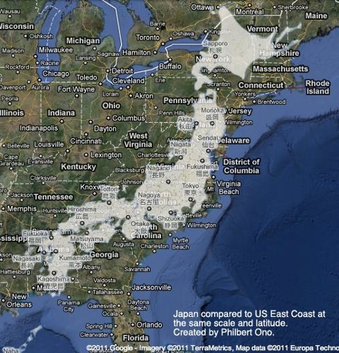
A related map comparison that blew my mind and left me feeling I understood things a little better, is East coast of USA vs Japan:

https://photoguide.jp/log/wp-content/uploads/2012/04/JapanUS...

Re: The True Size of Africa (2015)

#189

>> The Good Design Grand Award, arguably Japan’s most prestigious award for design, went out to architect Hajime Narukawa’s completely groundbreaking design for a map of the world. His map, the AuthaGraph World Map, isn’t your average map of the globe: It’s a near-perfect representation of the continents and oceans as they exist on our spherical planet, all laid out on a two-dimensional surface. https://totravelistol…

Here is an interactive tool, that lets you center other projections on different countries, to see the effect of the distortions move about:

https://engaging-data.com/country-centered-map-projections/

From playing around with that, it would seem the design process for the map was to "center" japan, then fiddle around with the polar regions to make them more recognisable.

Post reply on HN