Earlier quoted context omitted.
They did. The US’ Oregon Territory went well above the 49th parallel (current US/Canada border on the West coast), in fact all the way to where Alaska is today (southern most point on the coast). https://en.m.wikipedia.org/wiki/Oregon_boundary_dispute
Well, they didn't, though. They certainly claimed it as did the British. However, when the dust settled, we got the border we have today.
Kitsault, Canada’s $50M 1980s ghost town
171–180 of 197 posts
Re: Kitsault, Canada’s $50M 1980s ghost town
#172Earlier quoted context omitted.
Looks like that chart doesn't contain information from the 80's. I found this chart where the 1980 price level and crash seems to be pretty significant: https://www.researchgate.net/figure/Historical-rhenium-metal...
That's rhenium, not molybdenum?
https://en.m.wikipedia.org/wiki/Silver_Thursday
Different metals are correlated too. There are charts at the end of
https://www.hwwi.org/fileadmin/hwwi/Publikationen/Research/P...
Re: Kitsault, Canada’s $50M 1980s ghost town
#173This could be the excellent site for a re-education camp for the unvaccinated ;)
Re: Kitsault, Canada’s $50M 1980s ghost town
#174Re: Kitsault, Canada’s $50M 1980s ghost town
#175Re: Kitsault, Canada’s $50M 1980s ghost town
#176Earlier quoted context omitted.
Let’s start a hacker news town!
Uhm, The infra looks super depressing... https://www.google.ca/maps/place/Kitsault,+BC+V0J+3T0,+Canad...
Re: Kitsault, Canada’s $50M 1980s ghost town
#177Earlier quoted context omitted.
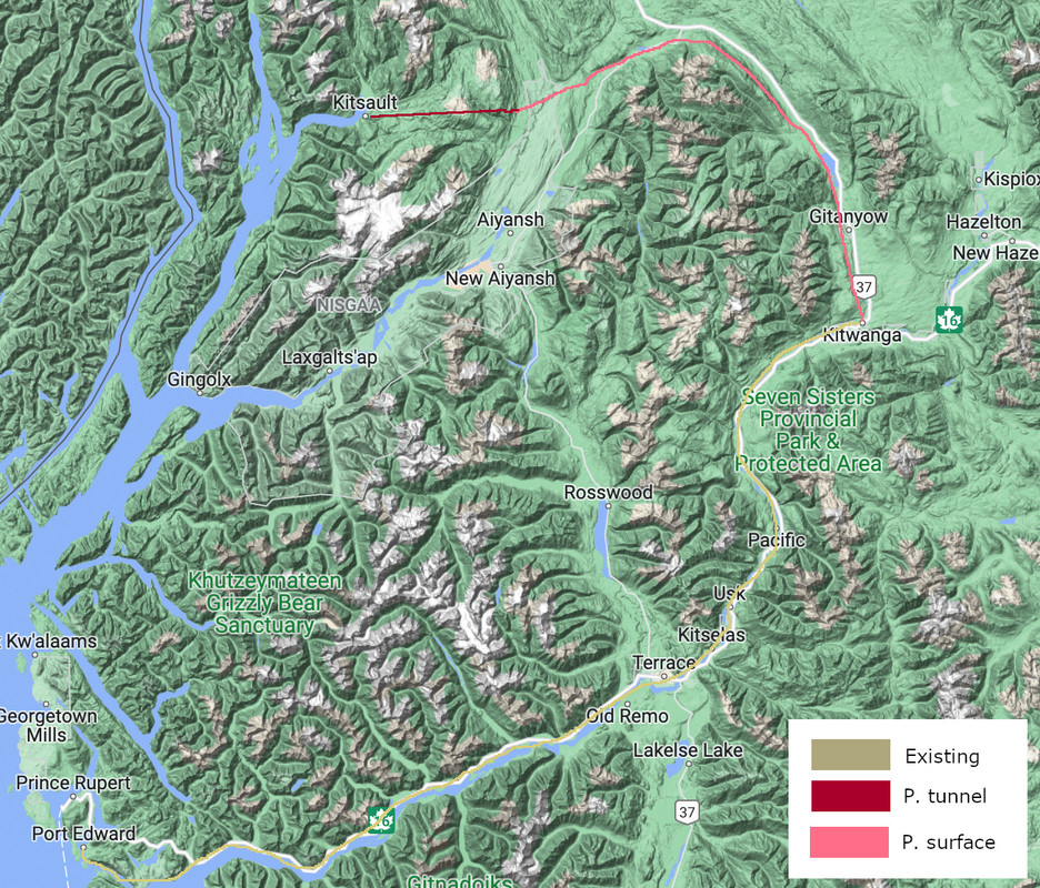
Due to spherical geometry, Prince Rupert is closer to Asia than any other reasonable North American port (sorry, Skagway) south of Anchorage. Kitsault is just up the inlet, and much easier to reach (crossing the Coast Mountains sunk Prince Rupert). It also happens to be easier (lower) to cross the Rockies (CA-16) when you're north of Prince George, so Kitsault could possibly have better access to Chicago than does, s…
There's rail access to Port Edward (just a couple miles from Prince Rupert) currently, going by what you can see in Google Maps. Looks like it follows a pretty flat route, though it winds around to follow the shorelines / rivers. I wonder how much sea level rise or flooding it would take to inundate that rail line and the Yellowhead highway? They seem like they're barely above water level now. Using Kisault as a port…
There is a railroad, but that is a windy, two-track railroad for the last ~200 kilometers from Kitwanga to Port Edward, with associated capacity limits and costs. To reach Kitsault from the relatively wide, flat Nisga'a Highway corridor, you need a tunnel of about 25 kilometers, but this could fit four or more tracks and run a much straighter, faster course. You can clearly see the difference:
Re: Kitsault, Canada’s $50M 1980s ghost town
#178Re: Kitsault, Canada’s $50M 1980s ghost town
#179Needs to be a Lost se/prequel filmed there
Re: Kitsault, Canada’s $50M 1980s ghost town
#180Earlier quoted context omitted.
Seems like a ferry would make sense to access it. BC already has a ton of those.
Ferry service is expensive infrastructure. Who would pay?