Live data from Hacker News

Roman Roads (2017)

sashamaps.net

161–166 of 166 posts

Re: Roman Roads (2017)

#161
post #29
post #7

How can it take 2 months on foot, yet only 1 month per horse, when a horse can only travel between 25-35 miles a day, which is not twice as far as a human can travel in a day, but about equal?

Horses would often be swapped out at stations when a wealthy person would have to travel very quickly across a long distance. Maybe this is an average since the speed with which horsemen could travel would depend on the rate at which they exchanged their horses. In an extreme example from the year 9 BC, the future emperor Tiberius traveled on the Roman Roads 330 miles (531 km) between northern Italy and modern day Ma…

Yes, for wealthy people who could swap out horses. If it was just a regular person like you or I with a horse, it wouldn’t increase your speed and even slow you down.

Horses were used for pulling or carrying loads, they are only faster on short high speeds, not long distances
Re: Roman Roads (2017)

#162
post #31
post #7

How can it take 2 months on foot, yet only 1 month per horse, when a horse can only travel between 25-35 miles a day, which is not twice as far as a human can travel in a day, but about equal?

With baggage, a typical human can only travel about 12-17 miles a day (half that of a horse)

Not really, 40km or 50km is easily doable, there are multiple events laying multiple days in which this is done.

You are thinking about military marches, which include supplies, setting up camp etc.

Re: Roman Roads (2017)

#163
post #126

Earlier quoted context omitted.

>We've used that a while ago to render a few pretty images with our graph visualization library, but runtime is prohibitive I wonder if anyone's tried running it with the Tokyo transit system.

At least the subways seem not that bad: https://www.yworks.com/assets/images/blog/tokyo.1e410d12c2.s... There are more here in the article (clicking an image opens a slideshow): https://www.yworks.com/blog/automatic-metro-map-generation

>At least the subways seem not that bad:

That's only a very small fraction of the transit system in the Tokyo metro area. There's over 800 stations, and over 100 train lines.

Re: Roman Roads (2017)

#164
post #5

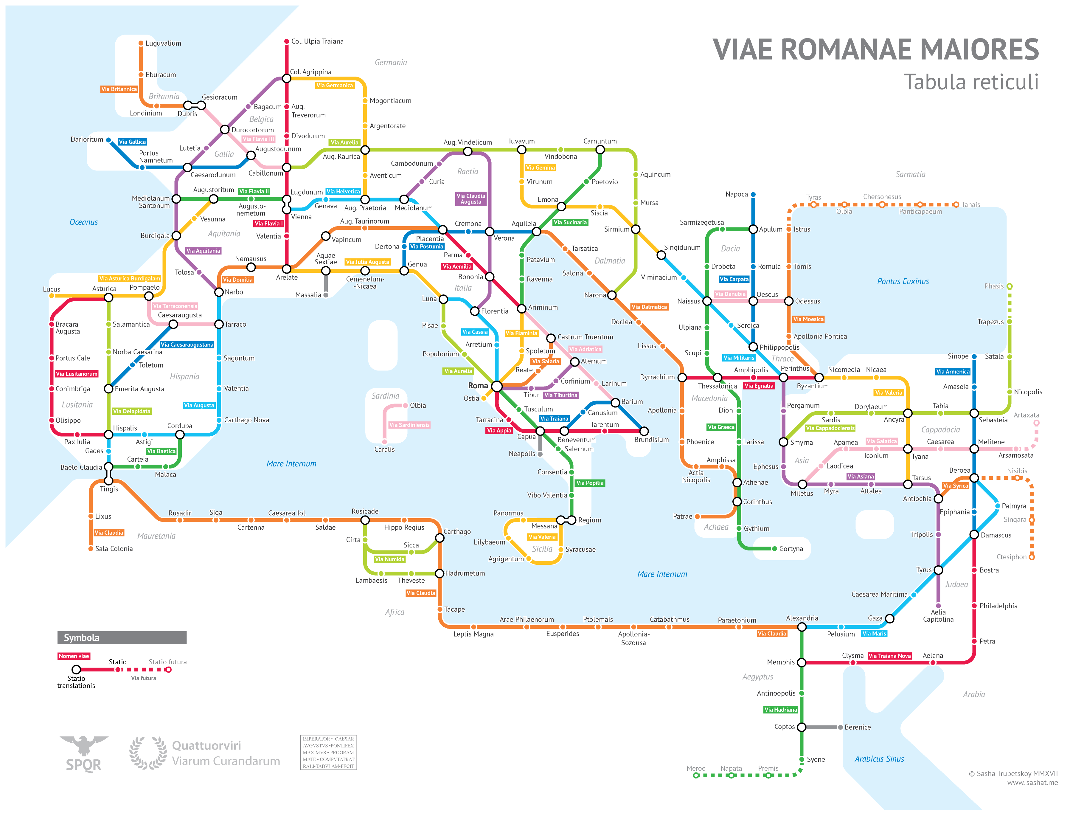
That's really well done! I have no comment on the accuracy but it really highlights just how the Romans integrated new areas into the central empire through transportation (goods, ideas, and armies). I will also call out the road in Africa called "Caeserea lol"

That would presumably be the city of Caesarea in Mauretania[0] which was the capital of that province. According to the Wikipedia article for the modern town at that site[1], it was also called Iol in ancient times. [0]: https://en.wikipedia.org/wiki/Caesarea_in_Mauretania [1]: https://en.wikipedia.org/wiki/Cherchell

Iol makes more sense than lol.

Thanks for clarifying!

Re: Roman Roads (2017)

#166
post #83

Earlier quoted context omitted.

When I was a boy scout (so 16 -18 yo) we were walking as a team 50-70 km per day and could sustain that for 2-3 days. More perhaps, but there was nowhere to go any further. We were wearing 20 kg in rather uncomfortable backpacks. On forced marches we could keep 7-8 km/h speed. And sometime we have practiced legionary walk which is alternating 200 steps jogging and 700 steps walking. One of the badges was for walking…

They also have a forced march event here where participants do 100km in 24h but it doesn't look easy https://mammutmarsch.de/

And doesn't sound like fun at all. Especially given the connotation of a "forced march".
Post reply on HN