Anyone have similar links for sounds?
National Park Service sound maps: https://www.nps.gov/subjects/sound/soundmap.htm
National Transportation Noise Map: https://maps.dot.gov/BTS/NationalTransportationNoiseMap/
161–170 of 200 posts
National Park Service sound maps: https://www.nps.gov/subjects/sound/soundmap.htm
National Transportation Noise Map: https://maps.dot.gov/BTS/NationalTransportationNoiseMap/
Is it a rendering artifact or something, that the left half of the United States is entirely darker than the right half? Like a line was drawn down the middle.
Nope, just that the western US is less densely populated than the eastern side of the country and that is directly reflected in the amount of light pollution.
Earlier quoted context omitted.
Probably the most noticable change in recent years is the replacement of mercury-vapor streetlights with the yellow-orange sodium-vapor lights, or with orangish LEDs (although some use blueish LEDs that are not that great for light pollution). In terms of actual legal requirements, Bavaria prohibits sky beams/searchlights directed upwards, and the illumination of facades of public buildings between 11pm and morning.
yellow-orange sodium-vapor lights are terrible for anyone who's not an astronomer. The sharp output spectrum prevents humans from seeing color
Even with wide spectrum lights, turning them down is going to suppress colors anyway.
It would be really great if this and other kinds of geospatial data were more open and easily mashed-up. Let's say I wanted to find a nice tract of land to buy (Zillow), which has good hiking trails (AllTrails), low light pollution for stargazing (lightpollutonmap.info), and maybe a dirt airstrip (vfrmaps) to fly into. Currently, I have to have four browser windows open with each site. There's no way to mash this dat…
I question the accuracy of this when 19.41869, -92.06075 supposedly has enormous light pollution. What would be the cause of this?
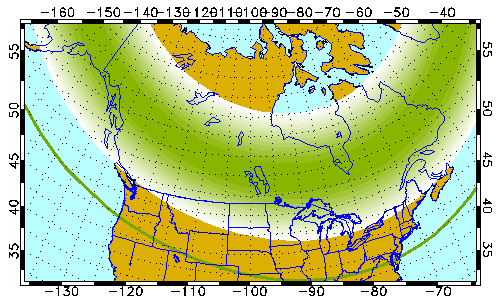
This is a bit tangential, but should be a pretty good aurora over North America tomorrow (Sat Apr 24) night -- visible on the horizon as far south as Salem, OR to Annapolis, MD: https://www.gi.alaska.edu/monitors/aurora-forecast (forecast is for the UTC day, so the prior overnight for NA)
I live in Maryland. I can't determine from the link how to tell if its projected to be visible there.
https://www.gi.alaska.edu/modules/custom/aurora-forecast/ima...
That's a direct link to the map as of this post. Unfortunately we have rain in the forecast here (I also live in MD).
I question the accuracy of this when 19.41869, -92.06075 supposedly has enormous light pollution. What would be the cause of this?