Live data from Hacker News

3D map of the Czech Republic, made from 12.5cm/px imagery (2017)

mapy.cz

101–110 of 123 posts

Re: 3D map of the Czech Republic, made from 12.5cm/px imagery (2017)

#101
post #94

Earlier quoted context omitted.

Or just don’t use it? These sorts of comments always ignore the bidirectional relationship between websites and web users. They don’t owe you anything, you’re just another customer with a choice to make.

Quoted post unavailable.

Remember that 'hacker news' used to be 'startup news'.

In any case, please write that program that you promised here. If it takes you longer than overnight, that's fine.
Re: 3D map of the Czech Republic, made from 12.5cm/px imagery (2017)

#102
post #98
post #97

Earlier quoted context omitted.

im talking about making an (FOSS) alternative front end, to an ostensibly free service, that fixes the bugs for them. what the fuck are you on about?

I think it's you who needs an attitude adjustment.

No post body was provided.

Re: 3D map of the Czech Republic, made from 12.5cm/px imagery (2017)

#103
post #26

Very nice! Obligatory and shameless self promotion everytime the topic of 3D maps comes up: I recently created a web app to visualize GPS tracking files in a 3D terrain. You can upload your GPX or FIT files and it generates the 3D Terrain using Babylon.js It's called https://cubetrek.com

I recently created a web app to visualize GPS tracking files Off topic, but since you work with GPS tracking files, perhaps you can recommend a GPS tracking device for me. Until last year, I used one I got around 2005 that was about half the size of a pack of cigarettes. You turned it on, and it would start logging waypoints at 10 minute intervals to a standard text tracking file on a microSD card. I could unload tha…

Why not a dedicated phone? A small app like https://github.com/mendhak/gpslogger and use it in airplane mode. Add a prepaid SIM card so that you can use it as a backup in case of emergency.

That's basically what I'm doing to record my bike rides, with the exception that I leave the display and mobile internet on, since I use it as my bike computer. In my case it lasts around 3 hours, but the screen is at max brightness and there's a continuous websocket connection to my server, GPS is recorded in realtime, accelerometer and magnetic field multiple times a second.

So I guess that if I'd only record GPS once a minute with the screen off and no mobile connection that battery would last for more than a day.

You could also use it as a camera.

Plus, when you get home, you connect it to wifi and let it upload the data to your server.

I mean a cheap phone with a big battery.

Re: 3D map of the Czech Republic, made from 12.5cm/px imagery (2017)

#104

Some places to see: - Rattay from Kingdom Come: Deliverance: https://en.mapy.cz/zakladni?m3d=1&height=399&yaw=57&pitch=-2... - ArmA II / DayZ map (hovering above Chernogorsk): https://en.mapy.cz/zakladni?m3d=1&height=3369&yaw=-14&pitch=... - Church moved by 841 meters in 1975, artificial lake (ex-coal mine) opened in 2020: https://en.mapy.cz/zakladni?m3d=1&height=303&yaw=-16&pitch=-... - Military training area, Doupo…

“Check out this big artificial lake and this church that was moved on train tracks once”

(Goes to investigate)

There's a frickin wizard tower next door, you're burying the lede!

https://en.mapy.cz/zakladni?moje-mapy&m3d=1&height=675&yaw=1...

Re: 3D map of the Czech Republic, made from 12.5cm/px imagery (2017)

#105
post #81
post #9

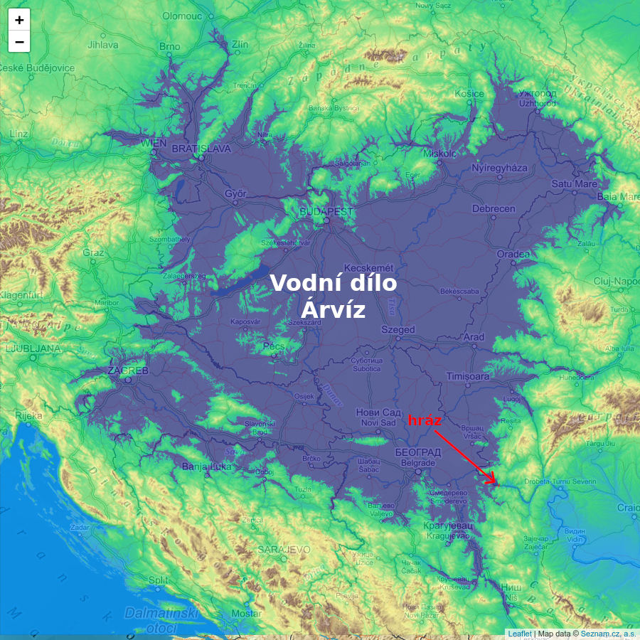
And the practical application of data like these: https://prehrada.hrach.eu/en.html

let me guess it's proposed by someone from Brno

No, I (the author) am from Prague. However, I have something much better for people from Brno. Also, Hungary, Croatia, Serbia and neighboring countries.

https://www.abclinuxu.cz/images/screenshots/1/0/250401-pouzi...

It is actually a recovery of a previous natural state: https://en.wikipedia.org/wiki/Pannonian_Sea

Here is a writeup on how to create your own dam simulation: https://www-abclinuxu-cz.translate.goog/blog/jenda/2021/4/po...

It actually has some commercial applications, we use very similar software for simulating radar coverage.

Re: 3D map of the Czech Republic, made from 12.5cm/px imagery (2017)

#106

Some places to see: - Rattay from Kingdom Come: Deliverance: https://en.mapy.cz/zakladni?m3d=1&height=399&yaw=57&pitch=-2... - ArmA II / DayZ map (hovering above Chernogorsk): https://en.mapy.cz/zakladni?m3d=1&height=3369&yaw=-14&pitch=... - Church moved by 841 meters in 1975, artificial lake (ex-coal mine) opened in 2020: https://en.mapy.cz/zakladni?m3d=1&height=303&yaw=-16&pitch=-... - Military training area, Doupo…

“Check out this big artificial lake and this church that was moved on train tracks once” (Goes to investigate) There's a frickin wizard tower next door, you're burying the lede! https://en.mapy.cz/zakladni?moje-mapy&m3d=1&height=675&yaw=1...

Beautiful!

https://en.wikipedia.org/wiki/Hn%C4%9Bv%C3%ADn_Castle

Re: 3D map of the Czech Republic, made from 12.5cm/px imagery (2017)

#107

Earlier quoted context omitted.

Yes, that's implicit to the complaint: "too much tracking and profiling being requested: won't use." And then you post a comment letting others know, in the hopes that they do better on their own websites because they see people voice the fact that they'll bounce on unreasonable tracking modals. They don't owe me anything, I don't owe them anything, and when someone with whom we have no debt relationship one way or t…

I suppose I could understand this complaint more if this was an unusual sight to behold, but surely you see this pattern a million times a day like the rest of society? I guess it just seems like it's a little overly pedantic, like those people that insist every intersection be replaced with a roundabout because it's more efficient for traffic. It misses the point. I think the law requiring websites to show the stupi…

No, I don't? And I doubt "the rest of society" does either?

(Most sites that show a consent banner tend to still "just work" even if you don't click any of the buttons - which is a fine way to comply with an idiotic law. They don't throw up a full page "give us your data before we show you anything" =)

Re: 3D map of the Czech Republic, made from 12.5cm/px imagery (2017)

#108

Earlier quoted context omitted.

“Check out this big artificial lake and this church that was moved on train tracks once” (Goes to investigate) There's a frickin wizard tower next door, you're burying the lede! https://en.mapy.cz/zakladni?moje-mapy&m3d=1&height=675&yaw=1...

Beautiful! https://en.wikipedia.org/wiki/Hn%C4%9Bv%C3%ADn_Castle

There is a castle you can rent for camping outside of Brno.

https://en.mapy.cz/zakladni?m3d=1&height=305&yaw=148&pitch=-...

Re: 3D map of the Czech Republic, made from 12.5cm/px imagery (2017)

#109

Earlier quoted context omitted.

Doesn't PDOK provide 8 cm resolution photos of The Netherlands?

Recently at an OSM meetup with the local government in Aachen (Germany), they mentioned that some imagery they shot was deemed too invasive and only used internally. I thought that was 10cm, but now checking what is available, looks like I was wrong! Probably it was 5-7cm then? Or maybe this was rather about the imagery available from different angles, so you can see into gardens from different directions? In iD I se…

That is indeed awful, you're right. I remember that satellietdataportaal.nl or something like that allowed access to uncompressed files, maybe they're better. I'll see if I can find my old credentials and compare.

But yeah, compared to those 10 cm images, that can't be effective 7.5 cm/px.

Related: Apple Maps uses some data source that is ridiculously high res for my street. They've updated the image now sadly, but for a while I saw a gangly brown haired silhouette chasing two blonde haired kids across the street. I was super sure that was me and my kids; slanted shadows gave the right relative sizes, too. Cool and creepy at the same time.

Re: 3D map of the Czech Republic, made from 12.5cm/px imagery (2017)

#110

Some places to see: - Rattay from Kingdom Come: Deliverance: https://en.mapy.cz/zakladni?m3d=1&height=399&yaw=57&pitch=-2... - ArmA II / DayZ map (hovering above Chernogorsk): https://en.mapy.cz/zakladni?m3d=1&height=3369&yaw=-14&pitch=... - Church moved by 841 meters in 1975, artificial lake (ex-coal mine) opened in 2020: https://en.mapy.cz/zakladni?m3d=1&height=303&yaw=-16&pitch=-... - Military training area, Doupo…

Zooming in on the lower basin of the pumped storage reservoir switches the map from showing the filled basin to an empty basin!
Post reply on HN