Live data from Hacker News

North Korean ICBM launch detected using GPS

twitter.com

11–20 of 101 posts

Re: North Korean ICBM launch detected using GPS

#11
post #7

Is it possible someone could explain as if to a small child what data can be collected from GPS which shows this effect. I don't understand.

GPS signals go through the ionosphere on their way from the satelites. The ionosphere causes distortions in the signal. If you want to achieve the best navigational accuracy you need to account for these distortions.

These distortions are not constant. They change from time to time. There are many different ways to account for them. One of the most accurate solution is to keep a GPS receiver on a well known location. Since you know that this receiver haven’t moved you can use the signal measured to estimate the parameters of the ionosphere between that station and the satelite.

Normally these signals are used to correct GPS navigational solutions. You take the closest station to your moving receiver and assume that whatever way the ionosphere was distorting for that station will do the same for your receiver too. This is valuable so there are network of such GPS stations in a lot of places.

Here they use the data collected by these stations differently. Instead of correcting a navigational solution they visualise the measured state of the ionosphere as seen by a bunch of these stations.

Re: North Korean ICBM launch detected using GPS

#12
Isn't the ionosphere already past the burn-out phase of a ballistic missile? I.e. by the time the rocket gets there it is just a glorified harpoon. Or perhaps that doesn't matter as anything of this size travelling at this speed would cause detectable disturbance?

Re: North Korean ICBM launch detected using GPS

#13
post #7

Is it possible someone could explain as if to a small child what data can be collected from GPS which shows this effect. I don't understand.

Section 2.1 in their linked paper (https://agupubs.onlinelibrary.wiley.com/doi/full/10.1029/201...) gives some clues. I think this is what's going on:

GPS receivers work by figuring out how far away they are from a number (>3) of GPS satellites. The receiver knows where the GPS satellites are (since the satellites broadcast their orbit parameters) so if a receiver knows how far it is from several satellites it can work out where it is itself.

Now, as the GPS satellite signals travel through Earth's atmosphere, they can be slowed down by different atmospheric effects. A slower signal will cause the receiver to think it's farther away from a satellite than it really is, so the receiver might estimate that it's position has changed a little bit. However, if you know the receiver's position hasn't change (maybe it's fixed in place to a big rock), then you can attribute the receiver's measured "change in position" to a change in atmosphere characteristics.

In this paper, they seem to have lots of fixed GPS receivers all over the place. By looking at all of them together, they can make a sort of map of the atmosphere characters in a part of the sky that's affected by rocket launches. The authors see these big ripples emanating from a Falcon Heavy launch in the US and this tweet shows those same ripples emanating from a launch site in North Korea.

Re: North Korean ICBM launch detected using GPS

#14
post #3

>Missiles make ionospheric disturbances that GPS records. The yellow ripple is the ionospheric disturbance. Where can I read more about the meta level concept of "isopheric disturbances"? (Because I suspect I'll find this has been done by military intelligence for a long time then rediscovered by so called "arms control" wonks who insist on putting their code into the public domain.)

The second tweet in the linked thread links to the paper which inspired them: https://agupubs.onlinelibrary.wiley.com/doi/full/10.1029/201... > who insist on putting their code into the public domain You say that as if there is something wrong with that.

" /s", spotted on my end.

Re: North Korean ICBM launch detected using GPS

#15
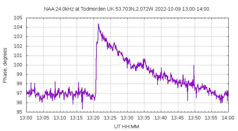
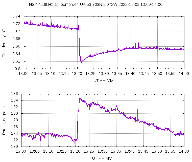
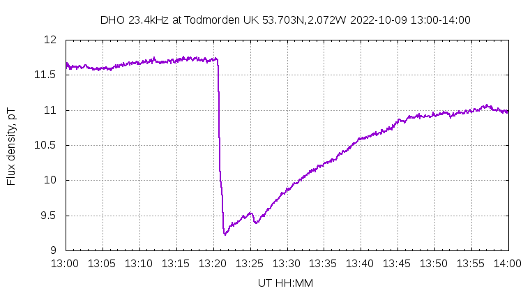
Related: last month's [0] gamma-ray burst also had interesting, measurable effects on the ionosphere,

https://gcn.gsfc.nasa.gov/gcn3/32744.gcn3 ("GRB221009A: Detection as sudden ionospheric disturbances (SID)")

https://www.qsl.net/df3lp/grb221009/KLM_grb221009a_magnitude... (from the above link)

http://abelian.org/vlf/grb221009a-DHO.png

http://abelian.org/vlf/grb221009a-NAA.png

http://abelian.org/vlf/grb221009a-NSY.png

[0] https://news.ycombinator.com/item?id=33215572 ("Record-breaking gamma-ray burst possibly most powerful explosion ever recorded")

This was detected with VLF radio, but I wonder if this kind of event also has an effect on GPS signals? The time-of-arrival of astrophysical gamma rays isn't uniform across the earth.

Re: North Korean ICBM launch detected using GPS

#16
post #11
post #7

Is it possible someone could explain as if to a small child what data can be collected from GPS which shows this effect. I don't understand.

GPS signals go through the ionosphere on their way from the satelites. The ionosphere causes distortions in the signal. If you want to achieve the best navigational accuracy you need to account for these distortions. These distortions are not constant. They change from time to time. There are many different ways to account for them. One of the most accurate solution is to keep a GPS receiver on a well known location.…

> One of the most accurate solution is to keep a GPS receiver on a well known location.

I wonder if a network of connected devices with a GPS-disciplined SDR receiver and a regular GPS one could work both as this project does plus as passive radar like the software that was recently taken down. The purpose would be to have much wider coverage along with redundancy and error correction.

Re: North Korean ICBM launch detected using GPS

#17
post #11

Earlier quoted context omitted.

GPS signals go through the ionosphere on their way from the satelites. The ionosphere causes distortions in the signal. If you want to achieve the best navigational accuracy you need to account for these distortions. These distortions are not constant. They change from time to time. There are many different ways to account for them. One of the most accurate solution is to keep a GPS receiver on a well known location.…

> One of the most accurate solution is to keep a GPS receiver on a well known location. I wonder if a network of connected devices with a GPS-disciplined SDR receiver and a regular GPS one could work both as this project does plus as passive radar like the software that was recently taken down. The purpose would be to have much wider coverage along with redundancy and error correction.

Such networks exist and make their data public. I think the equivalent you’re looking for is like LightningMaps, where there is real time reporting of observations instead of having to process recorded data to look back in time?

https://geodesy.noaa.gov/CORS_Map/

https://www.e-education.psu.edu/geog862/node/1830

https://learn.sparkfun.com/tutorials/how-to-build-a-diy-gnss...

Re: North Korean ICBM launch detected using GPS

#20

Quoted post unavailable.

That question implies that they couldn't land a nuke in Japan or South Korea currently. I think their current rockets have that capability.

They do - but that’s only part of the risk. The logistics around nuke delivery is more complicated (or course).

For the interested: “Arms Control Wonk” podcast and blog with Jeffery Lewis and Aaron Stein are good resources.

Post reply on HN