"2018" post.
Rethinking GPS: Engineering next-gen location at Uber (2018)
11–20 of 69 posts
Re: Rethinking GPS: Engineering next-gen location at Uber (2018)
#12Cool, so it looks like they take the “raw” GPS location (after the GPS module does processing to spit out a lat/long) and applies statistical methods with a model of the actual 3D geometry. Seems like a smart way to improve the accuracy from “userspace”. This reminds me of the Comma.ai project, Laika [0]. Since they have access to the raw GPS module data (Ie the actual timings of each received satellite transmitting)…
[0] https://developer.android.com/guide/topics/sensors/gnss
[1] https://developer.android.com/reference/android/location/Gns...
Re: Rethinking GPS: Engineering next-gen location at Uber (2018)
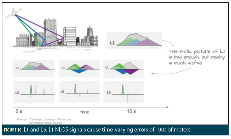
#13L5 GPS will address the multipath-in-urban-canyon problem that Uber worked on.
I don’t know much about L5. How does it do so?
Re: Rethinking GPS: Engineering next-gen location at Uber (2018)
#14L5 GPS will address the multipath-in-urban-canyon problem that Uber worked on.
I don’t know much about L5. How does it do so?
[0] https://insidegnss-com.exactdn.com/wp-content/uploads/2021/0...
[1] https://insidegnss.com/end-game-for-urban-gnss-googles-use-o...
Re: Rethinking GPS: Engineering next-gen location at Uber (2018)
#15Google explores these techniques as well. They're critical to improving accuracy in urban areas where you don't have line of sight to satellites (this is why your GNSS (AKA GPS) location is terrible whenever you're in a city). Here's [0] a cool gif visualizing the principle of GNSS ray tracing taken from one of Google's blog posts [1]. Here's an article with more information about Google's techniques [2]. [0] https:/…
Re: Rethinking GPS: Engineering next-gen location at Uber (2018)
#16Earlier quoted context omitted.
I don’t know much about L5. How does it do so?
To oversimplify: It's on a different frequency and so will be subject to different forms of error. You can average the results of L1 and L5 to get a more accurate position.
Re: Rethinking GPS: Engineering next-gen location at Uber (2018)
#17Re: Rethinking GPS: Engineering next-gen location at Uber (2018)
#18Re: Rethinking GPS: Engineering next-gen location at Uber (2018)
#19Google explores these techniques as well. They're critical to improving accuracy in urban areas where you don't have line of sight to satellites (this is why your GNSS (AKA GPS) location is terrible whenever you're in a city). Here's [0] a cool gif visualizing the principle of GNSS ray tracing taken from one of Google's blog posts [1]. Here's an article with more information about Google's techniques [2]. [0] https:/…
Re: Rethinking GPS: Engineering next-gen location at Uber (2018)
#20L5 GPS will address the multipath-in-urban-canyon problem that Uber worked on.